
Topografische Karte Yamanouchi
Interaktive Karte
Klicken Sie auf die Karte, um die Höhe anzuzeigen.
Über diese Karte
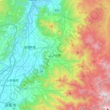
Name: Topografische Karte Yamanouchi, Höhe, Relief.
Ort: Yamanouchi, Shimotakai County, Nagano Prefecture, Japan (36.66571 138.38338 36.82465 138.64215)
Durchschnittliche Höhe: 942 m
Minimale Höhe: 305 m
Maximale Höhe: 2.303 m
Shimotakai District, in northern mountainous Nagano Prefecture, comprises Yamanouchi town, Kijimadaira Village, and Nozawaonsen Village. Yamanouchi is the largest of these. More than 90% of Yamanouchi is covered by mountains and forests. The town measures approximately 39 kilometers east-west and 12 kilometers north-south (266 square kilometers), and has an elevation ranging from 424 meters to 2341 meters. The surrounding area is known for its forest therapy.
Andere topografische Karten
Klicken Sie auf eine Karte, um ihre Topografie, ihre Höhe und ihr Relief anzuzeigen.
Nozawaonsen
Nozawaonsen, Shimotakai County, Nagano Prefecture, Chubu Region, 389-2502, Japan
Durchschnittliche Höhe: 710 m
Biwa Lake
Japan > Shimotakai County > Yamanouchi
Biwa Lake, Yamanouchi, Shimotakai County, Nagano Prefecture, Japan
Durchschnittliche Höhe: 1.368 m