
Spenden
Rüsten Sie sich für Ihr nächstes Abenteuer:
Als Amazon-Partner erhält diese Website eine Provision für qualifizierte Käufe, ohne zusätzliche Kosten für Sie.
Topografische Karte Nozawaonsen
Klicken Sie auf die Karte, um die Höhe anzuzeigen.
Spenden
Rüsten Sie sich für Ihr nächstes Abenteuer:
Als Amazon-Partner erhält diese Website eine Provision für qualifizierte Käufe, ohne zusätzliche Kosten für Sie.
Nozawaonsen
Nozawaonsen is located in mountainous northeastern Nagano Prefecture, about one hour's drive from Nagano City. To the south it borders Kijimadaira along the ridge of Mount Kenashi. To the west side the Chikuma River, the longest river in Japan, which forms a border of the village with the city of Iiyama. The north and the east borders Sakae village. The altitude of Nozawaonsen ranges from 300m above sea level at the lowest, to about 600m in the village, and 1,650m at the peak of Mount Kenashi.
Spenden
Rüsten Sie sich für Ihr nächstes Abenteuer:
Als Amazon-Partner erhält diese Website eine Provision für qualifizierte Käufe, ohne zusätzliche Kosten für Sie.
Über diese Karte
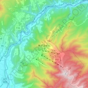
Name: Topografische Karte Nozawaonsen, Höhe, Relief.
Durchschnittliche Höhe: 710 m
Minimale Höhe: 278 m
Maximale Höhe: 1.635 m
Spenden
Rüsten Sie sich für Ihr nächstes Abenteuer:
Als Amazon-Partner erhält diese Website eine Provision für qualifizierte Käufe, ohne zusätzliche Kosten für Sie.