
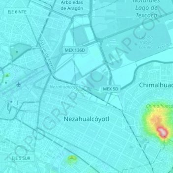
Topografische Karte Nezahualcóyotl
Interaktive Karte
Klicken Sie auf die Karte, um die Höhe anzuzeigen.
Über diese Karte
Name: Topografische Karte Nezahualcóyotl, Höhe, Relief.
Ort: Nezahualcóyotl, State of Mexico, Mexico (19.36621 -99.06799 19.49878 -98.96587)
Durchschnittliche Höhe: 2.235 m
Minimale Höhe: 2.220 m
Maximale Höhe: 2.536 m
The municipality has a territory of 63.44 km2, 81% of which is occupied by the city, which consists of 86 neighborhoods called colonias. The rest is part of the Federal Zone of the Ex-Basin of Texcoco. The municipality is flat with only one elevation reading 1,220 meters above sea level. The Los Remedios and a brand of the Churubusco River run through here. At the far northeast is a remnant of Lake Texcoco and an artificial lake was built here as part of the Parque del Puebla to serve as an ecological reserve. The climate is temperate with a fairly cold winter and rain mostly falling between June and October. Average temperature is about 15C with temperatures as high as 34C and as low as −5C. The area has little to no native wild flora and fauna due to the fact that it was underwater until the 20th century and the area is nearly completely urbanized. However, in winter a number of bird species such as cranes and storks pass through.
Andere topografische Karten
Klicken Sie auf eine Karte, um ihre Topografie, ihre Höhe und ihr Relief anzuzeigen.
Papalotla
Papalotla, State of Mexico, 56050, Mexico
Durchschnittliche Höhe: 2.265 m
Texcoco de Mora
Mexico > State of Mexico > Texcoco
Texcoco de Mora, Texcoco, State of Mexico, 56100, Mexico
Durchschnittliche Höhe: 2.448 m
Ciudad Satélite
Mexico > State of Mexico > Naucalpan de Juárez
Ciudad Satélite, Naucalpan de Juárez, State of Mexico, 53100, Mexico
Durchschnittliche Höhe: 2.299 m
Nevado de Toluca
Mexico > State of Mexico > Toluca
Nevado de Toluca, Toluca, State of Mexico, Mexico
Durchschnittliche Höhe: 4.271 m
Barrio la Cascada (Barrio del Varal)
Mexico > State of Mexico > Temascaltepec
Barrio la Cascada (Barrio del Varal), Temascaltepec, State of Mexico, Mexico
Durchschnittliche Höhe: 1.872 m
Ciudad López Mateos
Mexico > State of Mexico > Atizapán de Zaragoza
Ciudad López Mateos, Atizapán de Zaragoza, State of Mexico, 52940, Mexico
Durchschnittliche Höhe: 2.426 m
Interlomas
Mexico > State of Mexico > Huixquilucan
Interlomas, Huixquilucan, State of Mexico, 52760, Mexico
Durchschnittliche Höhe: 2.656 m
Teotihuacán
Teotihuacán, State of Mexico, 55845, Mexico
Durchschnittliche Höhe: 2.346 m
Valle de Bravo
Mexico > State of Mexico > Valle de Bravo
Valle de Bravo, State of Mexico, 51200, Mexico
Durchschnittliche Höhe: 1.914 m
Ojo de Agua
Mexico > State of Mexico > Tecámac
Ojo de Agua, Tecámac, State of Mexico, 55770, Mexico
Durchschnittliche Höhe: 2.297 m
Rancho San Dimas
Mexico > State of Mexico > San Antonio la Isla
Rancho San Dimas, San Antonio la Isla, State of Mexico, 52220, Mexico
Durchschnittliche Höhe: 2.585 m
Tlalnepantla de Baz
Tlalnepantla de Baz, State of Mexico, Mexico
Durchschnittliche Höhe: 2.323 m
Cerro Prieto
Mexico > State of Mexico > Isidro Fabela
Cerro Prieto, Isidro Fabela, State of Mexico, 04830, Mexico
Durchschnittliche Höhe: 3.415 m
Lerma de Villada
Mexico > State of Mexico > Lerma
Lerma de Villada, Lerma, State of Mexico, 52006, Mexico
Durchschnittliche Höhe: 2.577 m
Endexhe
Mexico > State of Mexico > Lerma > Endexhe
Endexhe, Lerma, State of Mexico, 52050, Mexico
Durchschnittliche Höhe: 2.740 m
Texcalyacac
Mexico > State of Mexico > Texcalyacac
Texcalyacac, State of Mexico, Mexico
Durchschnittliche Höhe: 2.632 m
Cuautitlán
Mexico > State of Mexico > Cuautitlán
Cuautitlán, State of Mexico, Mexico
Durchschnittliche Höhe: 2.258 m
Las Cruces
Las Cruces, Temascaltepec, State of Mexico, Mexico
Durchschnittliche Höhe: 3.206 m
Monarch Butterfly Biosphere Reserve
Mexico > State of Mexico > Villa de Allende
Monarch Butterfly Biosphere Reserve, Villa de Allende, State of Mexico, Mexico
Durchschnittliche Höhe: 2.461 m
Temascaltepec
Mexico > State of Mexico > Temascaltepec
Temascaltepec, State of Mexico, Mexico
Durchschnittliche Höhe: 2.604 m
Jocotitlán
Mexico > State of Mexico > Jocotitlán
Jocotitlán, State of Mexico, Mexico
Durchschnittliche Höhe: 2.674 m
Cacalomacan
Mexico > State of Mexico > Toluca > Cacalomacan
Cacalomacan, Toluca, State of Mexico, 50265, Mexico
Durchschnittliche Höhe: 2.790 m
Tlalnepantla
Mexico > State of Mexico > Tlalnepantla de Baz
Tlalnepantla, Tlalnepantla de Baz, State of Mexico, 54000, Mexico
Durchschnittliche Höhe: 2.358 m
Predio de los Albertocos
Mexico > State of Mexico > Temamatla > Temamatla > Predio de los Albertocos
Predio de los Albertocos, Temamatla, State of Mexico, Mexico
Durchschnittliche Höhe: 2.313 m
Santa María Tulpetlac
Mexico > State of Mexico > Ecatepec de Morelos > Santa María Tulpetlac
Santa María Tulpetlac, Ecatepec de Morelos, State of Mexico, 55400, Mexico
Durchschnittliche Höhe: 2.280 m
La Marquesa
Mexico > State of Mexico > La Marquesa
La Marquesa, Ocoyoacac, State of Mexico, 05750, Mexico
Durchschnittliche Höhe: 3.138 m
San Franciso de Asís
San Franciso de Asís, State of Mexico, Mexico
Durchschnittliche Höhe: 890 m
Huixquilucan
Mexico > State of Mexico > Huixquilucan
Huixquilucan, State of Mexico, Mexico
Durchschnittliche Höhe: 2.921 m
Timilpan
Mexico > State of Mexico > Timilpan
Timilpan, State of Mexico, Mexico
Durchschnittliche Höhe: 2.704 m
Tepotzotlán
Tepotzotlán, State of Mexico, Mexico
Durchschnittliche Höhe: 2.400 m
Santa Catarina
Mexico > State of Mexico > Lerma
Santa Catarina, Lerma, State of Mexico, 52055, Mexico
Durchschnittliche Höhe: 2.602 m
Ozumba
Mexico > State of Mexico > Ozumba
Ozumba, State of Mexico, 56800, Mexico
Durchschnittliche Höhe: 2.353 m
Zinacantepec
Mexico > State of Mexico > Zinacantepec
Zinacantepec, State of Mexico, Mexico
Durchschnittliche Höhe: 3.103 m
Barrio Paraiso
Mexico > State of Mexico > Huixquilucan > Barrio Paraiso
Barrio Paraiso, Huixquilucan, State of Mexico, 52773, Mexico
Durchschnittliche Höhe: 2.679 m
Trojes
Mexico > State of Mexico > Luvianos > Trojes
Trojes, Luvianos, State of Mexico, 51440, Mexico
Durchschnittliche Höhe: 1.143 m
Teoloyucan
Mexico > State of Mexico > Teoloyucan
Teoloyucan, State of Mexico, Mexico
Durchschnittliche Höhe: 2.253 m
Ixtapaluca
Ixtapaluca, State of Mexico, Mexico
Durchschnittliche Höhe: 2.407 m
Chapultepec
Mexico > State of Mexico > Chapultepec
Chapultepec, State of Mexico, Mexico
Durchschnittliche Höhe: 2.587 m
Tequixquiac
Mexico > State of Mexico > Tequixquiac
Tequixquiac, State of Mexico, Mexico
Durchschnittliche Höhe: 2.296 m
Naucalpan
Mexico > State of Mexico > Naucalpan de Juárez
Naucalpan, Naucalpan de Juárez, State of Mexico, 53370, Mexico
Durchschnittliche Höhe: 2.459 m
Nevado de Toluca
Nevado de Toluca, Tenango del Valle, State of Mexico, Mexico
Durchschnittliche Höhe: 4.037 m
Nextlalpan
Nextlalpan, State of Mexico, Mexico
Durchschnittliche Höhe: 2.245 m
Popocatépetl
Mexico > State of Mexico > Atlautla
Popocatépetl, Atlautla, State of Mexico, Mexico
Durchschnittliche Höhe: 4.810 m