
Topografische Karte Texcoco de Mora
Interaktive Karte
Klicken Sie auf die Karte, um die Höhe anzuzeigen.
Über diese Karte
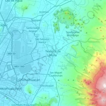
Name: Topografische Karte Texcoco de Mora, Höhe, Relief.
Ort: Texcoco de Mora, Texcoco, State of Mexico, 56100, Mexico (19.35443 -99.04213 19.67443 -98.72213)
Durchschnittliche Höhe: 2.448 m
Minimale Höhe: 2.223 m
Maximale Höhe: 4.121 m
Tescoco lies about 25 km east of the centre of Mexico City. Major elevations in the municipality include the Tlaloc Mountain (4,500 meters) the Tetzcutzinco, Moyotepec and Tecuachacho. Most elevations are named after the major community to be found on them. There are also a number of small canyons. Part of the municipality used to be covered by Lake Texcoco, but most of this lake has since been drained. The rivers that fed it, such as the Cozcacuaco, the Chapingo and the San Bernardino still exist.