
Topografische Karte Northfield
Interaktive Karte
Klicken Sie auf die Karte, um die Höhe anzuzeigen.
Über diese Karte
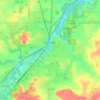
Name: Topografische Karte Northfield, Höhe, Relief.
Ort: Northfield, Rice County, Minnesota, 55057, United States (44.42084 -93.22144 44.48590 -93.12889)
Durchschnittliche Höhe: 300 m
Minimale Höhe: 268 m
Maximale Höhe: 347 m
According to the United States Census Bureau, the city has an area of 8.61 square miles (22.30 km2); 8.56 square miles (22.17 km2) is land and 0.05 square miles (0.13 km2) is water. The peak elevation is about 912 feet.
Andere topografische Karten
Klicken Sie auf eine Karte, um ihre Topografie, ihre Höhe und ihr Relief anzuzeigen.
Dundas
United States > Minnesota > Rice County
Dundas, Rice County, Minnesota, United States
Durchschnittliche Höhe: 297 m
Heath Creek
United States > Minnesota > Rice County > Northfield
Heath Creek, Northfield, Rice County, Minnesota, 55057, United States
Durchschnittliche Höhe: 292 m
Northfield
United States > Minnesota > Rice County
Northfield, Dundas, Rice County, Minnesota, 55057, United States
Durchschnittliche Höhe: 300 m