
Topografische Karte Casula
Interaktive Karte
Klicken Sie auf die Karte, um die Höhe anzuzeigen.
Casula
Casula is the first suburb immediately south of Liverpool on the Hume Highway and the Main Southern railway line between Sydney and Melbourne. Casula consists of undulating, gently rolling land, with elevations across the suburb being mostly between 30 and 70 metres above sea level. The Georges River forms the eastern boundary of the suburb, and its western bank is paralleled by a relatively steep escarpment.
Über diese Karte
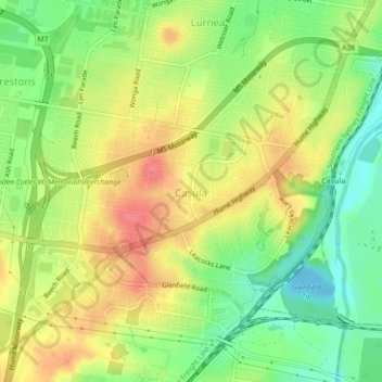
Name: Topografische Karte Casula, Höhe, Relief.
Durchschnittliche Höhe: 34 m
Minimale Höhe: -9 m
Maximale Höhe: 68 m
Andere topografische Karten
Klicken Sie auf eine Karte, um ihre Topografie, ihre Höhe und ihr Relief anzuzeigen.
George Kendall Park Dog Off-Leash Area
Australia > New South Wales > Sydney
Durchschnittliche Höhe: 15 m