
Topografische Karte Poole
Interaktive Karte
Klicken Sie auf die Karte, um die Höhe anzuzeigen.
Über diese Karte
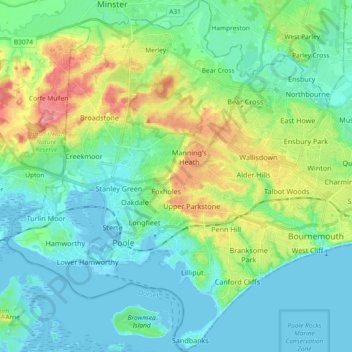
Name: Topografische Karte Poole, Höhe, Relief.
Durchschnittliche Höhe: 23 m
Minimale Höhe: -7 m
Maximale Höhe: 89 m
Andere topografische Karten
Klicken Sie auf eine Karte, um ihre Topografie, ihre Höhe und ihr Relief anzuzeigen.
St Catherine's Hill
United Kingdom > England > Bournemouth, Christchurch and Poole > Christchurch
Durchschnittliche Höhe: 10 m
Holdenhurst
United Kingdom > England > Bournemouth, Christchurch and Poole > Bournemouth
Durchschnittliche Höhe: 12 m
Bear Cross
United Kingdom > England > Bournemouth, Christchurch and Poole > Bournemouth
Durchschnittliche Höhe: 30 m
East Parley Common
United Kingdom > England > Bournemouth, Christchurch and Poole > Hurn
Durchschnittliche Höhe: 13 m
Bournemouth
United Kingdom > England > Bournemouth, Christchurch and Poole
Durchschnittliche Höhe: 21 m
Hengistbury Head
United Kingdom > England > Bournemouth, Christchurch and Poole
In 1910 the first international aviation meeting ever held in Britain took place on a specially laid out aerodrome consisting of a mile of grassland between the "Double Dykes" and the nearby village of Tuckton. About twenty pioneer aviators from around the world participated in various competitions including…
Durchschnittliche Höhe: 0 m
Talbot Village
United Kingdom > England > Bournemouth, Christchurch and Poole > Bournemouth
Durchschnittliche Höhe: 40 m
Upton Heath Nature Reserve
United Kingdom > England > Bournemouth, Christchurch and Poole > Poole
Durchschnittliche Höhe: 40 m
Holes Bay
United Kingdom > England > Bournemouth, Christchurch and Poole > Poole
Durchschnittliche Höhe: 4 m