
Topografische Karte Hengistbury Head
Interaktive Karte
Klicken Sie auf die Karte, um die Höhe anzuzeigen.
Über diese Karte
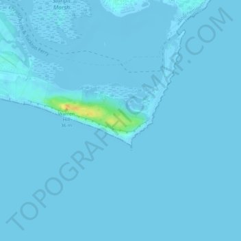
Name: Topografische Karte Hengistbury Head, Höhe, Relief.
Durchschnittliche Höhe: 0 m
Minimale Höhe: -4 m
Maximale Höhe: 27 m
In 1910 the first international aviation meeting ever held in Britain took place on a specially laid out aerodrome consisting of a mile of grassland between the "Double Dykes" and the nearby village of Tuckton. About twenty pioneer aviators from around the world participated in various competitions including spot landing, altitude tests and speed trials (both for the fastest and slowest circuit).
Andere topografische Karten
Klicken Sie auf eine Karte, um ihre Topografie, ihre Höhe und ihr Relief anzuzeigen.
Poole
United Kingdom > England > Bournemouth, Christchurch and Poole > Merley
Poole, Merley, Bournemouth, Christchurch and Poole, England, United Kingdom
Durchschnittliche Höhe: 23 m
Bournemouth
United Kingdom > England > Bournemouth, Christchurch and Poole > Wick
Bournemouth, Wick, Bournemouth, Christchurch and Poole, England, United Kingdom
Durchschnittliche Höhe: 17 m
Christchurch
United Kingdom > England > Bournemouth, Christchurch and Poole > Hurn
Christchurch, Hurn, Bournemouth, Christchurch and Poole, England, United Kingdom
Durchschnittliche Höhe: 18 m
East Parley Common
United Kingdom > England > Bournemouth, Christchurch and Poole > Hurn
East Parley Common, Hurn, Bournemouth, Christchurch and Poole, England, United Kingdom
Durchschnittliche Höhe: 13 m
Bournemouth
United Kingdom > England > Bournemouth, Christchurch and Poole
Bournemouth, Bournemouth, Christchurch and Poole, England, BH2 6EG, United Kingdom
Durchschnittliche Höhe: 21 m
Poole
United Kingdom > England > Bournemouth, Christchurch and Poole
Poole, Bournemouth, Christchurch and Poole, England, BH15 1SU, United Kingdom
Durchschnittliche Höhe: 16 m
Merley
United Kingdom > England > Bournemouth, Christchurch and Poole
Merley, Bournemouth, Christchurch and Poole, England, BH21 3AQ, United Kingdom
Durchschnittliche Höhe: 34 m
Holes Bay
United Kingdom > England > Bournemouth, Christchurch and Poole > Poole
Holes Bay, Sterte, Poole, Bournemouth, Christchurch and Poole, South West England, England, BH15 2BD, United Kingdom
Durchschnittliche Höhe: 4 m
Upton Heath Nature Reserve
United Kingdom > England > Bournemouth, Christchurch and Poole > Poole
Upton Heath Nature Reserve, Lytchett Minster and Upton, Poole, Bournemouth, Christchurch and Poole, South West England, England, BH17 7BQ, United Kingdom
Durchschnittliche Höhe: 40 m
Kinson
United Kingdom > England > Bournemouth, Christchurch and Poole
Kinson, Bournemouth, Christchurch and Poole, England, BH10 7AY, United Kingdom
Durchschnittliche Höhe: 26 m
Christchurch
United Kingdom > England > Bournemouth, Christchurch and Poole > Christchurch
Christchurch, Bournemouth, Christchurch and Poole, South West England, England, United Kingdom
Durchschnittliche Höhe: 8 m
Hurn
United Kingdom > England > Bournemouth, Christchurch and Poole
Hurn, Bournemouth, Christchurch and Poole, England, United Kingdom
Durchschnittliche Höhe: 12 m
Talbot Village
United Kingdom > England > Bournemouth, Christchurch and Poole
Talbot Village, Bournemouth, Christchurch and Poole, England, BH10 4JA, United Kingdom
Durchschnittliche Höhe: 40 m
Wick
United Kingdom > England > Bournemouth, Christchurch and Poole
Wick, Bournemouth, Christchurch and Poole, England, BH6 4LP, United Kingdom
Durchschnittliche Höhe: 4 m
Highcliffe-on-Sea
United Kingdom > England > Bournemouth, Christchurch and Poole
Highcliffe-on-Sea, Bournemouth, Christchurch and Poole, England, BH23 5GD, United Kingdom
Durchschnittliche Höhe: 19 m