
Spenden
Rüsten Sie sich für Ihr nächstes Abenteuer:
Als Amazon-Partner erhält diese Website eine Provision für qualifizierte Käufe, ohne zusätzliche Kosten für Sie.
Topografische Karte Airdrie
Klicken Sie auf die Karte, um die Höhe anzuzeigen.
Spenden
Rüsten Sie sich für Ihr nächstes Abenteuer:
Als Amazon-Partner erhält diese Website eine Provision für qualifizierte Käufe, ohne zusätzliche Kosten für Sie.
Airdrie
Airdrie's name first appeared in the Register of the Great Seal of Scotland (Latin: Registrum Magni Sigilii Regum Scotorum) in 1373 as Ardre. By 1546 it had become Ardry and by 1587 it was known as Ardrie. In 1630 it finally appeared in the Register as Airdrie. Given the topography of the area, the most likely interpretation is that the name derives from the Gaelic An Àrd Ruigh meaning a level height or high pasture land. Another possibility is from the Gaelic An Àrd Àirighe meaning a sheiling, a summer pasture/shepherd's hut. A third possibility is the Gaelic Ard Reidh meaning a high plain. A further, non-Gaelic alternative is the Brythonic, i.e. Cumbric or North Welsh, ard tref (becoming ardre by process of assimilation), meaning a high steading or farmstead, which would date back to the times of the Kingdom of Strathclyde, before the expansion of Gaelic or English speech into the region. Airthrey Castle in Stirlingshire may have a similar derivation.
Spenden
Rüsten Sie sich für Ihr nächstes Abenteuer:
Als Amazon-Partner erhält diese Website eine Provision für qualifizierte Käufe, ohne zusätzliche Kosten für Sie.
Über diese Karte
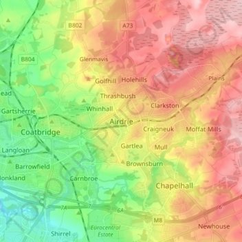
Name: Topografische Karte Airdrie, Höhe, Relief.
Ort: Airdrie, North Lanarkshire, Scotland, ML6 6BU, United Kingdom (55.82578 -4.01959 55.90578 -3.93959)
Durchschnittliche Höhe: 136 m
Minimale Höhe: 48 m
Maximale Höhe: 228 m
Spenden
Rüsten Sie sich für Ihr nächstes Abenteuer:
Als Amazon-Partner erhält diese Website eine Provision für qualifizierte Käufe, ohne zusätzliche Kosten für Sie.
Andere topografische Karten
Klicken Sie auf eine Karte, um ihre Topografie, ihre Höhe und ihr Relief anzuzeigen.
Cumbernauld
United Kingdom > Scotland > North Lanarkshire
Cumbernauld's name probably comes from the Gaelic comar nan allt, meaning "meeting of the burns or streams". There are differing views as to the etymology of this. One theory is that from its high point in the Central Belt, its streams flow both west to the River Clyde and east to the Firth of Forth so…
Durchschnittliche Höhe: 113 m
Strathclyde Park
United Kingdom > Scotland > North Lanarkshire > Motherwell
Durchschnittliche Höhe: 44 m
Spenden
Rüsten Sie sich für Ihr nächstes Abenteuer:
Als Amazon-Partner erhält diese Website eine Provision für qualifizierte Käufe, ohne zusätzliche Kosten für Sie.
Cumbernauld
United Kingdom > Scotland > North Lanarkshire
Cumbernauld's name probably comes from the Gaelic comar nan allt, meaning "meeting of the burns or streams". There are differing views as to the etymology of this. One theory is that from its high point in the Central Belt, its streams flow both west to the River Clyde and east to the Firth of Forth so…
Durchschnittliche Höhe: 113 m
Forrestburn Reservoir
United Kingdom > Scotland > North Lanarkshire > Bentfoot
Durchschnittliche Höhe: 231 m
Cumbernauld
United Kingdom > Scotland > North Lanarkshire
Cumbernauld's name probably comes from the Gaelic comar nan allt, meaning "meeting of the burns or streams". There are differing views as to the etymology of this. One theory is that from its high point in the Central Belt, its streams flow both west to the River Clyde and east to the Firth of Forth so…
Durchschnittliche Höhe: 113 m