
Spenden
Rüsten Sie sich für Ihr nächstes Abenteuer:
Als Amazon-Partner erhält diese Website eine Provision für qualifizierte Käufe, ohne zusätzliche Kosten für Sie.
Topografische Karte Prosto
Klicken Sie auf die Karte, um die Höhe anzuzeigen.
Spenden
Rüsten Sie sich für Ihr nächstes Abenteuer:
Als Amazon-Partner erhält diese Website eine Provision für qualifizierte Käufe, ohne zusätzliche Kosten für Sie.
Über diese Karte
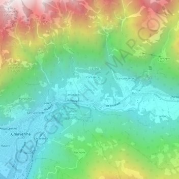
Name: Topografische Karte Prosto, Höhe, Relief.
Durchschnittliche Höhe: 865 m
Minimale Höhe: 284 m
Maximale Höhe: 2.093 m
Spenden
Rüsten Sie sich für Ihr nächstes Abenteuer:
Als Amazon-Partner erhält diese Website eine Provision für qualifizierte Käufe, ohne zusätzliche Kosten für Sie.
Andere topografische Karten
Klicken Sie auf eine Karte, um ihre Topografie, ihre Höhe und ihr Relief anzuzeigen.
Livigno
Only three roads lead to the town. Two link to Switzerland, one through the Forcola di Livigno, elevation 2,315 m (7,595 ft) and open in summer only, and the second through the Munt la Schera Tunnel. The third road connects to other parts of Italy through the Foscagno Pass, elevation 2,291 m (7,516 ft).
Durchschnittliche Höhe: 2.388 m
Spenden
Rüsten Sie sich für Ihr nächstes Abenteuer:
Als Amazon-Partner erhält diese Website eine Provision für qualifizierte Käufe, ohne zusätzliche Kosten für Sie.
Spenden
Rüsten Sie sich für Ihr nächstes Abenteuer:
Als Amazon-Partner erhält diese Website eine Provision für qualifizierte Käufe, ohne zusätzliche Kosten für Sie.
Bormio
For the World Cup race in December 2017, the Stelvio started at an elevation of 2,255 m (7,398 ft), with a vertical drop of 1,010 m (3,314 ft) and course length of 3.27 km (2.03 mi). The winning time of Italian Dominik Paris was just under two minutes, yielding an average speed of 100.66 km/h (62.5 mph) and a…
Durchschnittliche Höhe: 2.018 m
Spenden
Rüsten Sie sich für Ihr nächstes Abenteuer:
Als Amazon-Partner erhält diese Website eine Provision für qualifizierte Käufe, ohne zusätzliche Kosten für Sie.
Spenden
Rüsten Sie sich für Ihr nächstes Abenteuer:
Als Amazon-Partner erhält diese Website eine Provision für qualifizierte Käufe, ohne zusätzliche Kosten für Sie.
Bormio
For the World Cup race in December 2017, the Stelvio started at an elevation of 2,255 m (7,398 ft), with a vertical drop of 1,010 m (3,314 ft) and course length of 3.27 km (2.03 mi). The winning time of Italian Dominik Paris was just under two minutes, yielding an average speed of 100.66 km/h (62.5 mph) and a…
Durchschnittliche Höhe: 2.018 m
Livigno
Only three roads lead to the town. Two link to Switzerland, one through the Forcola di Livigno, elevation 2,315 m (7,595 ft) and open in summer only, and the second through the Munt la Schera Tunnel. The third road connects to other parts of Italy through the Foscagno Pass, elevation 2,291 m (7,516 ft).
Durchschnittliche Höhe: 2.388 m
Spenden
Rüsten Sie sich für Ihr nächstes Abenteuer:
Als Amazon-Partner erhält diese Website eine Provision für qualifizierte Käufe, ohne zusätzliche Kosten für Sie.
Bormio
For the World Cup race in December 2017, the Stelvio started at an elevation of 2,255 m (7,398 ft), with a vertical drop of 1,010 m (3,314 ft) and course length of 3.27 km (2.03 mi). The winning time of Italian Dominik Paris was just under two minutes, yielding an average speed of 100.66 km/h (62.5 mph) and a…
Durchschnittliche Höhe: 2.018 m
Spenden
Rüsten Sie sich für Ihr nächstes Abenteuer:
Als Amazon-Partner erhält diese Website eine Provision für qualifizierte Käufe, ohne zusätzliche Kosten für Sie.