
Topografische Karte Lakeside
Interaktive Karte
Klicken Sie auf die Karte, um die Höhe anzuzeigen.
Über diese Karte
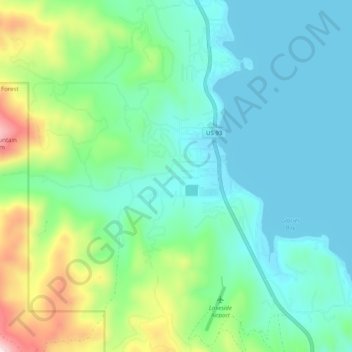
Name: Topografische Karte Lakeside, Höhe, Relief.
Ort: Lakeside, Flathead County, Montana, 59922, United States (47.98336 -114.25572 48.05011 -114.18376)
Durchschnittliche Höhe: 1.034 m
Minimale Höhe: 879 m
Maximale Höhe: 1.542 m
Andere topografische Karten
Klicken Sie auf eine Karte, um ihre Topografie, ihre Höhe und ihr Relief anzuzeigen.
Kalispell
United States > Montana > Flathead County
Kalispell, Flathead County, Montana, United States
Durchschnittliche Höhe: 934 m
Bowman Lake
United States > Montana > Flathead County
Bowman Lake, Flathead County, Montana, United States
Durchschnittliche Höhe: 1.639 m
Martin City
United States > Montana > Flathead County > Martin City
Martin City, Flathead County, Montana, 59926, United States
Durchschnittliche Höhe: 989 m
Columbia Falls
United States > Montana > Flathead County
Columbia Falls, Flathead County, Montana, 59912, United States
Durchschnittliche Höhe: 934 m
Mount Liebig
United States > Montana > Flathead County
Mount Liebig, Flathead County, Montana, United States
Durchschnittliche Höhe: 1.968 m
Whitefish
United States > Montana > Flathead County
Whitefish, Flathead County, Montana, United States
Durchschnittliche Höhe: 1.073 m
La Salle
United States > Montana > Flathead County > La Salle
La Salle, Flathead County, Montana, United States
Durchschnittliche Höhe: 906 m
Kalispell
United States > Montana > Flathead County > Kalispell
Kalispell, Flathead County, Montana, 59901-4451, United States
Durchschnittliche Höhe: 1.055 m
Agassiz Glacier
United States > Montana > Flathead County
Agassiz Glacier, Flathead County, Montana, United States
Durchschnittliche Höhe: 2.376 m
Vulture Glacier
United States > Montana > Flathead County
Vulture Glacier, Flathead County, Montana, United States
Durchschnittliche Höhe: 2.381 m