
Topografische Karte Cincinnati
Interaktive Karte
Klicken Sie auf die Karte, um die Höhe anzuzeigen.
Über diese Karte
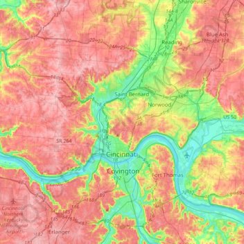
Name: Topografische Karte Cincinnati, Höhe, Relief.
Ort: Cincinnati, Hamilton County, Ohio, United States (39.05206 -84.71239 39.22104 -84.36958)
Durchschnittliche Höhe: 222 m
Minimale Höhe: 139 m
Maximale Höhe: 293 m
Cincinnati has several standard modes of transportation including sidewalks, roads, public transit, bicycle paths and airports. The city's hills preclude the regular street grid common to many cities built up in the 19th century, and outside of the downtown basin, regular street grids are rare except for in patches of flat land where they are small and oriented according to topography.
Andere topografische Karten
Klicken Sie auf eine Karte, um ihre Topografie, ihre Höhe und ihr Relief anzuzeigen.
Symmes Township Park
United States > Ohio > Hamilton County > Loveland
Symmes Township Park, Loveland, Symmes Township, Hamilton County, Ohio, United States
Durchschnittliche Höhe: 226 m
Amberley Village
United States > Ohio > Hamilton County
Amberley Village, Hamilton County, Ohio, United States
Durchschnittliche Höhe: 226 m
Forest Park
United States > Ohio > Hamilton County
Forest Park, Hamilton County, Ohio, United States
Durchschnittliche Höhe: 234 m
Montgomery Heights
United States > Ohio > Hamilton County > Montgomery > Montgomery Heights
Montgomery Heights, Montgomery, Hamilton County, Ohio, 45242-5324, United States
Durchschnittliche Höhe: 241 m
Northgate
United States > Ohio > Hamilton County > Northgate
Northgate, Colerain Township, Hamilton County, Ohio, United States
Durchschnittliche Höhe: 264 m
Norwood
United States > Ohio > Hamilton County
Norwood, Hamilton County, Ohio, 45212, United States
Durchschnittliche Höhe: 196 m