
Topografische Karte Niagara River
Interaktive Karte
Klicken Sie auf die Karte, um die Höhe anzuzeigen.
Über diese Karte
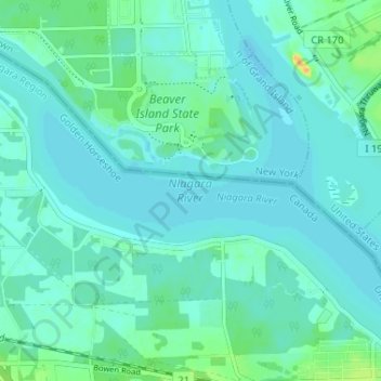
Name: Topografische Karte Niagara River, Höhe, Relief.
Durchschnittliche Höhe: 177 m
Minimale Höhe: 171 m
Maximale Höhe: 203 m
The river, which is occasionally described as a strait, is about 58 kilometres (36 mi) long and includes Niagara Falls in its course. The falls have moved approximately 11 kilometres (6.8 mi) upstream from the Niagara Escarpment in the last 12,000 years, resulting in a gorge below the falls. Today, the diversion of the river for electrical generation has significantly reduced the rate of erosion. The total drop in elevation along the river is 99 metres (325 ft). The Niagara Gorge extends downstream from the Falls and includes the Niagara Whirlpool and another section of rapids.
Andere topografische Karten
Klicken Sie auf eine Karte, um ihre Topografie, ihre Höhe und ihr Relief anzuzeigen.
Crystal Beach
Canada > Ontario > Niagara Region > Fort Erie
Crystal Beach, Fort Erie, Niagara Region, Golden Horseshoe, Ontario, L0S 1B0, Canada
Durchschnittliche Höhe: 181 m
Fort Erie
Canada > Ontario > Niagara Region > Fort Erie
Fort Erie, Niagara Region, Golden Horseshoe, Ontario, L2A 3S7, Canada
Durchschnittliche Höhe: 183 m
Stevensville
Canada > Ontario > Niagara Region > Fort Erie > Stevensville
Stevensville, Fort Erie, Niagara Region, Golden Horseshoe, Ontario, Canada
Durchschnittliche Höhe: 178 m