
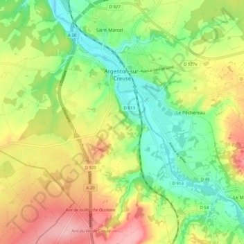
Topografische Karte Argenton-sur-Creuse
Interaktive Karte
Klicken Sie auf die Karte, um die Höhe anzuzeigen.
Über diese Karte
Name: Topografische Karte Argenton-sur-Creuse, Höhe, Relief.
Durchschnittliche Höhe: 164 m
Minimale Höhe: 97 m
Maximale Höhe: 252 m
Andere topografische Karten
Klicken Sie auf eine Karte, um ihre Topografie, ihre Höhe und ihr Relief anzuzeigen.
Châteauroux
France > Centre-Val de Loire > Indre > Châteauroux
Châteauroux, Indre, Centre-Val de Loire, France métropolitaine, 36000, France
Durchschnittliche Höhe: 153 m
Thenay
France > Centre-Val de Loire > Indre
Thenay, Le Blanc, Indre, Centre-Val de Loire, France métropolitaine, 36800, France
Durchschnittliche Höhe: 152 m
Buzançais
France > Centre-Val de Loire > Indre
Buzançais, Châteauroux, Indre, Centre-Val de Loire, France métropolitaine, 36500, France
Durchschnittliche Höhe: 130 m