
Topografische Karte Maloyaroslavets
Interaktive Karte
Klicken Sie auf die Karte, um die Höhe anzuzeigen.
Über diese Karte
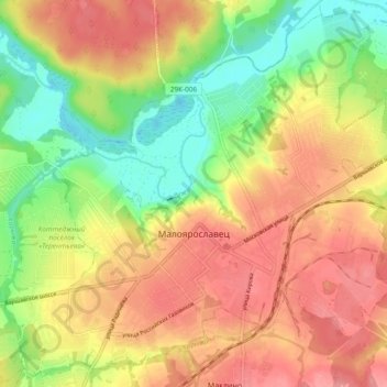
Name: Topografische Karte Maloyaroslavets, Höhe, Relief.
Durchschnittliche Höhe: 171 m
Minimale Höhe: 121 m
Maximale Höhe: 214 m
Andere topografische Karten
Klicken Sie auf eine Karte, um ihre Topografie, ihre Höhe und ihr Relief anzuzeigen.
Сляднево
Russia > Kaluga Oblast > Maloyaroslavetsky District
Сляднево, сельское поселение Юбилейный, Maloyaroslavetsky District, Kaluga Oblast, Central Federal District, Russia
Durchschnittliche Höhe: 199 m
Petrovo
Russia > Kaluga Oblast > Maloyaroslavetsky District
Petrovo, сельское поселение Деревня Захарово, Maloyaroslavetsky District, Kaluga Oblast, Central Federal District, Russia
Durchschnittliche Höhe: 205 m