
Topografische Karte Squaw Valley
Interaktive Karte
Klicken Sie auf die Karte, um die Höhe anzuzeigen.
Über diese Karte
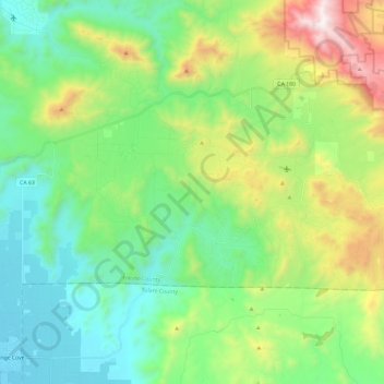
Name: Topografische Karte Squaw Valley, Höhe, Relief.
Ort: Squaw Valley, Fresno County, California, United States (36.65755 -119.30466 36.75426 -119.06844)
Durchschnittliche Höhe: 557 m
Minimale Höhe: 128 m
Maximale Höhe: 1.624 m
Squaw Valley (formerly, Squawvalley) is a census-designated place located in Fresno County, California, in the United States. As of the 2010 census, the CDP had a total population of 3,162, up from 2,691 at the 2000 census. Despite the similar name, it is not the location of Squaw Valley Ski Resort or the 1960 Winter Olympics. Squaw Valley is located 9 miles (14 km) north-northeast of Orange Cove and 30 miles (48 km) east of Fresno, at an elevation of 1,631 ft (497 m). The name is controversial because squaw is an ethnic and sexual slur, historically used for indigenous North American women.