
Topografische Karte Poprad
Interaktive Karte
Klicken Sie auf die Karte, um die Höhe anzuzeigen.
Poprad
International Poprad–Tatry Airport from 1938, is an airport with the highest elevations in Central Europe. It also offers scheduled flights to London.
Über diese Karte
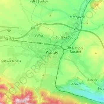
Name: Topografische Karte Poprad, Höhe, Relief.
Durchschnittliche Höhe: 699 m
Minimale Höhe: 584 m
Maximale Höhe: 932 m