Geolokalisieren

Topografische Karte Eustis

Klicken Sie auf die Karte, um die Höhe anzuzeigen.

Über diese Karte

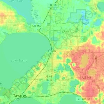
Name: Topografische Karte Eustis, Höhe, Relief.

Ort: Eustis, Lake County, Florida, United States (28.81103 -81.76213 28.89261 -81.63178)

Durchschnittliche Höhe: 28 m

Minimale Höhe: 9 m

Maximale Höhe: 60 m

Andere topografische Karten

Klicken Sie auf eine Karte, um ihre Topografie, ihre Höhe und ihr Relief anzuzeigen.

Mount Plymouth

United States > Florida > Lake County > Mount Plymouth

Durchschnittliche Höhe: 25 m

Astor

United States > Florida > Lake County

Durchschnittliche Höhe: 7 m

Lake Louisa

United States > Florida > Lake County > Clermont

Durchschnittliche Höhe: 31 m

Grand Island

United States > Florida > Lake County

Durchschnittliche Höhe: 25 m

Loch Leven

United States > Florida > Lake County > Mount Dora

Durchschnittliche Höhe: 50 m

Waits Junction

United States > Florida > Lake County

Durchschnittliche Höhe: 35 m

Slones Ridge

United States > Florida > Lake County

Durchschnittliche Höhe: 31 m

Sugarloaf Mountain

United States > Florida > Lake County

Durchschnittliche Höhe: 55 m

Yalaha

United States > Florida > Lake County > Yalaha

Durchschnittliche Höhe: 24 m

Lake Minneola

United States > Florida > Lake County > Clermont

Durchschnittliche Höhe: 30 m

Cassia

United States > Florida > Lake County

Durchschnittliche Höhe: 15 m

Mohawk

United States > Florida > Lake County > Minneola

Durchschnittliche Höhe: 48 m

Blue Lake

United States > Florida > Lake County > Eustis

Durchschnittliche Höhe: 44 m

Mount Plymouth

United States > Florida > Lake County

Durchschnittliche Höhe: 25 m

Grand Island

United States > Florida > Lake County

Durchschnittliche Höhe: 25 m

Harbor Shores

United States > Florida > Lake County

Durchschnittliche Höhe: 23 m

Big Pine Island

United States > Florida > Lake County

Durchschnittliche Höhe: 24 m

Lake Norris

United States > Florida > Lake County

Durchschnittliche Höhe: 14 m

Lisbon

United States > Florida > Lake County

Lisbon has low rolling landscape with elevations ranging from 30 ft to 60 ft.

Durchschnittliche Höhe: 22 m

Paisley

United States > Florida > Lake County > Paisley

Durchschnittliche Höhe: 25 m

Okahumpka

United States > Florida > Lake County > Okahumpka

Durchschnittliche Höhe: 28 m

Camp Ocala

United States > Florida > Lake County

Durchschnittliche Höhe: 16 m

Montverde Junction

United States > Florida > Lake County > Clermont

Durchschnittliche Höhe: 32 m

Manhatten

United States > Florida > Lake County

Durchschnittliche Höhe: 7 m

Vielen Dank für die Unterstützung dieser Website ❤️
Spenden

Sorrento

United States > Florida > Lake County > Sorrento

Durchschnittliche Höhe: 27 m

Astor

United States > Florida > Lake County

Durchschnittliche Höhe: 7 m

Yalaha

United States > Florida > Lake County > Tavares

Durchschnittliche Höhe: 24 m

Florence Lake

United States > Florida > Lake County

Durchschnittliche Höhe: 36 m

Sugarloaf Mountain

United States > Florida > Lake County

Durchschnittliche Höhe: 55 m

Ferndale

United States > Florida > Lake County > Ferndale

Durchschnittliche Höhe: 28 m

Manhatten

United States > Florida > Lake County

Durchschnittliche Höhe: 7 m

Silver Lake

United States > Florida > Lake County > Silver Lake

Durchschnittliche Höhe: 25 m

Manhatten

United States > Florida > Lake County

Durchschnittliche Höhe: 7 m

Altoona

United States > Florida > Lake County > Altoona

Durchschnittliche Höhe: 28 m

Sorrento

United States > Florida > Lake County > Sorrento

Durchschnittliche Höhe: 27 m

Rüsten Sie sich für Ihr nächstes Abenteuer:

🥄Titan-Besteck - Extrem leichtes und stabiles Essbesteck
👖Outdoor-Hosen - Atmungsaktive und robuste Hosen für Bergsteiger
😴Leichtschlafsäcke - Optimale Wärme bei geringem Packmaß
🚲Fahrradcomputer mit Karten - Navigation für Mountainbiker und Tourenfahrer
🎒Wanderrucksack 50L - Geräumiger Trekkingrucksack mit Komfortträgern

Als Amazon-Partner erhält diese Website eine Provision für qualifizierte Käufe, ohne zusätzliche Kosten für Sie.