
Topografische Karte Libertów
Interaktive Karte
Klicken Sie auf die Karte, um die Höhe anzuzeigen.
Über diese Karte
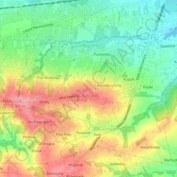
Name: Topografische Karte Libertów, Höhe, Relief.
Durchschnittliche Höhe: 270 m
Minimale Höhe: 223 m
Maximale Höhe: 323 m
Andere topografische Karten
Klicken Sie auf eine Karte, um ihre Topografie, ihre Höhe und ihr Relief anzuzeigen.
Werychów
Poland > Lesser Poland Voivodeship > Kraków County > Balice
Werychów, Balice, gmina Zabierzów, Kraków County, Lesser Poland Voivodeship, 31-083, Poland
Durchschnittliche Höhe: 238 m
Bielańsko-Tyniecki Park Krajobrazowy
Poland > Lesser Poland Voivodeship > Kraków County > Krakow
Bielańsko-Tyniecki Park Krajobrazowy, Krakow, gmina Liszki, Kraków County, Lesser Poland Voivodeship, Poland
Durchschnittliche Höhe: 239 m
Podzamcze
Poland > Lesser Poland Voivodeship > Kraków County > Korzkiew > Podzamcze
Podzamcze, Korzkiew, gmina Zielonki, Kraków County, Lesser Poland Voivodeship, Poland
Durchschnittliche Höhe: 321 m
Czernichów
Poland > Lesser Poland Voivodeship > Kraków County
Czernichów, gmina Czernichów, Kraków County, Lesser Poland Voivodeship, Poland
Durchschnittliche Höhe: 219 m
Kobylany
Poland > Lesser Poland Voivodeship > Kraków County
Kobylany, gmina Zabierzów, Kraków County, Lesser Poland Voivodeship, Poland
Durchschnittliche Höhe: 319 m
Radziszów
Poland > Lesser Poland Voivodeship > Kraków County
Radziszów, gmina Skawina, Kraków County, Lesser Poland Voivodeship, Poland
Durchschnittliche Höhe: 262 m