
Topografische Karte Crescent
Interaktive Karte
Klicken Sie auf die Karte, um die Höhe anzuzeigen.
Über diese Karte
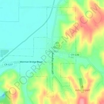
Name: Topografische Karte Crescent, Höhe, Relief.
Ort: Crescent, Pottawattamie County, Iowa, United States (41.35320 -95.87908 41.37648 -95.85014)
Durchschnittliche Höhe: 327 m
Minimale Höhe: 290 m
Maximale Höhe: 392 m
Andere topografische Karten
Klicken Sie auf eine Karte, um ihre Topografie, ihre Höhe und ihr Relief anzuzeigen.
Underwood
United States > Iowa > Pottawattamie County
Underwood, Pottawattamie County, Iowa, United States
Durchschnittliche Höhe: 338 m
Council Bluffs
United States > Iowa > Pottawattamie County
Council Bluffs, Pottawattamie County, Iowa, United States
Durchschnittliche Höhe: 315 m
Underwood
United States > Iowa > Pottawattamie County > Underwood > Underwood
Underwood, Pottawattamie County, Iowa, 51576, United States
Durchschnittliche Höhe: 344 m
Carson
United States > Iowa > Pottawattamie County
Carson, Pottawattamie County, Iowa, 51525, United States
Durchschnittliche Höhe: 341 m
Neola
United States > Iowa > Pottawattamie County
Neola, Pottawattamie County, Iowa, United States
Durchschnittliche Höhe: 343 m