
Topografische Karte Le Crêt
Interaktive Karte
Klicken Sie auf die Karte, um die Höhe anzuzeigen.
Über diese Karte
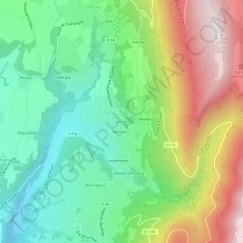
Name: Topografische Karte Le Crêt, Höhe, Relief.
Durchschnittliche Höhe: 799 m
Minimale Höhe: 426 m
Maximale Höhe: 1.411 m
Andere topografische Karten
Klicken Sie auf eine Karte, um ihre Topografie, ihre Höhe und ihr Relief anzuzeigen.
Brénaz
France > Auvergne-Rhône-Alpes > Ain > Arvière-en-Valromey
Brénaz, Arvière-en-Valromey, Belley, Ain, Auvergne-Rhône-Alpes, France métropolitaine, 01260, France
Durchschnittliche Höhe: 974 m
Vovray
France > Auvergne-Rhône-Alpes > Ain > Arvière-en-Valromey
Vovray, Chavornay, Arvière-en-Valromey, Belley, Ain, Auvergne-Rhône-Alpes, France métropolitaine, 01510, France
Durchschnittliche Höhe: 602 m
Romagnieu
France > Auvergne-Rhône-Alpes > Ain > Arvière-en-Valromey
Romagnieu, Virieu-le-Petit, Arvière-en-Valromey, Belley, Ain, Auvergne-Rhône-Alpes, France métropolitaine, 01260, France
Durchschnittliche Höhe: 707 m
Grand Colombier
France > Auvergne-Rhône-Alpes > Ain > Arvière-en-Valromey
Grand Colombier, Arvière-en-Valromey, Belley, Ain, Auvergne-Rhône-Alpes, France métropolitaine, France
Durchschnittliche Höhe: 1.235 m
Assin
France > Auvergne-Rhône-Alpes > Ain > Arvière-en-Valromey
Assin, Virieu-le-Petit, Arvière-en-Valromey, Belley, Ain, Auvergne-Rhône-Alpes, France métropolitaine, 01260, France
Durchschnittliche Höhe: 721 m