
Spenden
Rüsten Sie sich für Ihr nächstes Abenteuer:
Als Amazon-Partner erhält diese Website eine Provision für qualifizierte Käufe, ohne zusätzliche Kosten für Sie.
Topografische Karte Platina
Klicken Sie auf die Karte, um die Höhe anzuzeigen.
Spenden
Rüsten Sie sich für Ihr nächstes Abenteuer:
Als Amazon-Partner erhält diese Website eine Provision für qualifizierte Käufe, ohne zusätzliche Kosten für Sie.
Über diese Karte
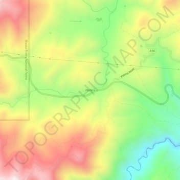
Name: Topografische Karte Platina, Höhe, Relief.
Ort: Platina, Shasta County, California, 96076, United States (40.33959 -122.91474 40.37959 -122.87474)
Durchschnittliche Höhe: 770 m
Minimale Höhe: 420 m
Maximale Höhe: 1.136 m
Spenden
Rüsten Sie sich für Ihr nächstes Abenteuer:
Als Amazon-Partner erhält diese Website eine Provision für qualifizierte Käufe, ohne zusätzliche Kosten für Sie.
Andere topografische Karten
Klicken Sie auf eine Karte, um ihre Topografie, ihre Höhe und ihr Relief anzuzeigen.
Redding
United States > California > Shasta County
The elevation in Redding is 495 feet (151 meters) on average, whereas anywhere to the north, east, or west of downtown ranges between 550 feet (170 m) and 800 feet (240 m) feet. Southern portions range between 400 feet (120 m) and 500 feet (150 m).
Durchschnittliche Höhe: 241 m
Redding
United States > California > Shasta County
The elevation in Redding is 495 feet (151 meters) on average, whereas anywhere to the north, east, or west of downtown ranges between 550 feet (170 m) and 800 feet (240 m) feet. Southern portions range between 400 feet (120 m) and 500 feet (150 m).
Durchschnittliche Höhe: 240 m
Spenden
Rüsten Sie sich für Ihr nächstes Abenteuer:
Als Amazon-Partner erhält diese Website eine Provision für qualifizierte Käufe, ohne zusätzliche Kosten für Sie.
Spenden
Rüsten Sie sich für Ihr nächstes Abenteuer:
Als Amazon-Partner erhält diese Website eine Provision für qualifizierte Käufe, ohne zusätzliche Kosten für Sie.
Whiskeytown-Shasta-Trinity National Recreation Area - Shasta Unit
United States > California > Shasta County
Durchschnittliche Höhe: 612 m
Lassen Volcanic National Park
United States > California > Shasta County
According to the Köppen climate classification system, Lassen Volcanic National Park has a Mediterranean-influenced warm-summer Humid continental climate (Dsb). According to the United States Department of Agriculture, the Plant Hardiness zone at Kohm Yah-mah-nee Visitor Center at 6,736 ft (2,053 m) elevation…
Durchschnittliche Höhe: 1.972 m
Spenden
Rüsten Sie sich für Ihr nächstes Abenteuer:
Als Amazon-Partner erhält diese Website eine Provision für qualifizierte Käufe, ohne zusätzliche Kosten für Sie.
Redding
United States > California > Shasta County
The elevation in Redding is 495 feet (151 meters) on average, whereas anywhere to the north, east, or west of downtown ranges between 550 and 800 feet (170 and 240 m). Southern portions range between 400 and 500 feet (120 and 150 m).
Durchschnittliche Höhe: 241 m
Spenden
Rüsten Sie sich für Ihr nächstes Abenteuer:
Als Amazon-Partner erhält diese Website eine Provision für qualifizierte Käufe, ohne zusätzliche Kosten für Sie.
Spenden
Rüsten Sie sich für Ihr nächstes Abenteuer:
Als Amazon-Partner erhält diese Website eine Provision für qualifizierte Käufe, ohne zusätzliche Kosten für Sie.
Lassen Volcanic National Park
United States > California > Shasta County
According to the Köppen climate classification system, Lassen Volcanic National Park has a Mediterranean-influenced warm-summer Humid continental climate (Dsb). According to the United States Department of Agriculture, the Plant Hardiness zone at Kohm Yah-mah-nee Visitor Center at 6,736 ft (2,053 m) elevation…
Durchschnittliche Höhe: 1.972 m
Palo Cedro
United States > California > Shasta County
Palo Cedro is located at 40°33′4″N 122°14′3″W / 40.55111°N 122.23417°W / 40.55111; -122.23417 (40.551091, −122.234255) at an elevation of 465 ft (143 m) above sea level.
Durchschnittliche Höhe: 157 m
Whiskeytown-Shasta-Trinity National Recreation Area - Shasta Unit
United States > California > Shasta County
Durchschnittliche Höhe: 612 m