
Topografische Karte La Ligottière
Interaktive Karte
Klicken Sie auf die Karte, um die Höhe anzuzeigen.
Über diese Karte
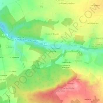
Name: Topografische Karte La Ligottière, Höhe, Relief.
Durchschnittliche Höhe: 137 m
Minimale Höhe: 88 m
Maximale Höhe: 189 m
Andere topografische Karten
Klicken Sie auf eine Karte, um ihre Topografie, ihre Höhe und ihr Relief anzuzeigen.
Le Haut Montas
France > Centre-Val de Loire > Indre-et-Loire > Marray
Le Haut Montas, Marray, Chinon, Indre-et-Loire, Centre-Val de Loire, France métropolitaine, 37370, France
Durchschnittliche Höhe: 145 m
Château de la Roche d'Alès
France > Centre-Val de Loire > Indre-et-Loire > Marray
Château de la Roche d'Alès, Marray, Chinon, Indre-et-Loire, Centre-Val de Loire, France métropolitaine, 37370, France
Durchschnittliche Höhe: 122 m