
Topografische Karte Alfred
Interaktive Karte
Klicken Sie auf die Karte, um die Höhe anzuzeigen.
Über diese Karte
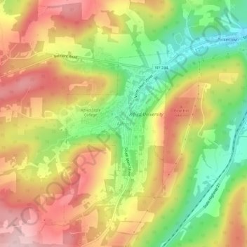
Name: Topografische Karte Alfred, Höhe, Relief.
Durchschnittliche Höhe: 604 m
Minimale Höhe: 484 m
Maximale Höhe: 712 m
The elevation of Alfred is about 1,700 feet (520 m) but rises to a high point of 2,355 feet (718 m) at the summit of Jericho Hill just south of the village. The hills greatly affect the weather in the region, which results in quick changes as well as different conditions in neighboring valleys.