
Topografische Karte Villa Imperial de Potosí
Interaktive Karte
Klicken Sie auf die Karte, um die Höhe anzuzeigen.
Über diese Karte
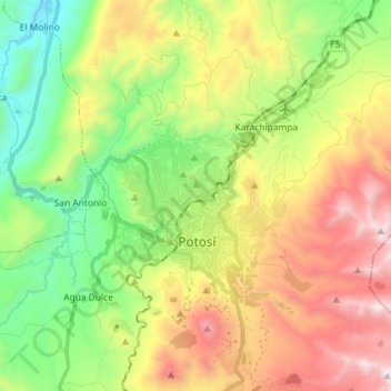
Name: Topografische Karte Villa Imperial de Potosí, Höhe, Relief.
Durchschnittliche Höhe: 4.048 m
Minimale Höhe: 3.367 m
Maximale Höhe: 5.017 m
Andere topografische Karten
Klicken Sie auf eine Karte, um ihre Topografie, ihre Höhe und ihr Relief anzuzeigen.
Cantumarca
Bolivia > Potosí > Villa Imperial de Potosí > Cantumarca
Cantumarca, Villa Imperial de Potosí, Provincia Tomás Frías, Potosí, 36, Bolivia
Durchschnittliche Höhe: 3.797 m