
Topografische Karte Liberty Island
Interaktive Karte
Klicken Sie auf die Karte, um die Höhe anzuzeigen.
Über diese Karte
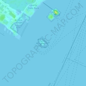
Name: Topografische Karte Liberty Island, Höhe, Relief.
Durchschnittliche Höhe: 0 m
Minimale Höhe: -1 m
Maximale Höhe: 17 m
Andere topografische Karten
Klicken Sie auf eine Karte, um ihre Topografie, ihre Höhe und ihr Relief anzuzeigen.
Manhattan
États-Unis d'Amérique > New York > New York County > New York
Manhattan, New York County, New York, États-Unis d'Amérique
Durchschnittliche Höhe: 16 m
Central Park
États-Unis d'Amérique > New York > New York County > New York
Central Park, New York County, New York, États-Unis d'Amérique
Durchschnittliche Höhe: 26 m
Battery Park
États-Unis d'Amérique > New York > New York County > New York
Battery Park, Manhattan Community Board 1, Manhattan, New York County, New York, 10004, États-Unis d'Amérique
Durchschnittliche Höhe: 3 m