
Topografische Karte Tver Oblast
Interaktive Karte
Klicken Sie auf die Karte, um die Höhe anzuzeigen.
Tver Oblast
Tver Oblast as a whole is characterized by flat terrain with alternating lowlands and highlands. In the western part of the province, occupying about one-third of its area is Valdai Hills, with elevations of 200–300 m above sea level. It is surrounded by depressions, lowlands have a height of 100–150 m highest point of the area has a height of 347 m, is located on a hill Tsninsky (The top of the Valdai). The low point (61 m) - the extreme north-west area of the river's edge Kunya (Russian: Кунья) on the border with the Novgorod Oblast.
Über diese Karte
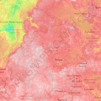
Name: Topografische Karte Tver Oblast, Höhe, Relief.
Ort: Tver Oblast, Central Federal District, Russia (54.55345 32.61444 59.67345 37.73444)
Durchschnittliche Höhe: 156 m
Minimale Höhe: 15 m
Maximale Höhe: 332 m
Andere topografische Karten
Klicken Sie auf eine Karte, um ihre Topografie, ihre Höhe und ihr Relief anzuzeigen.