
Topografische Karte Jackson Glacier
Interaktive Karte
Klicken Sie auf die Karte, um die Höhe anzuzeigen.
Über diese Karte
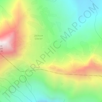
Name: Topografische Karte Jackson Glacier, Höhe, Relief.
Ort: Jackson Glacier, Glacier County, Montana, USA (48.59853 -113.70127 48.59863 -113.70117)
Durchschnittliche Höhe: 2.238 m
Minimale Höhe: 1.729 m
Maximale Höhe: 3.041 m
Andere topografische Karten
Klicken Sie auf eine Karte, um ihre Topografie, ihre Höhe und ihr Relief anzuzeigen.
Logan Glacier
Logan Glacier, Glacier County, Montana, USA
Durchschnittliche Höhe: 2.225 m
Elkhorn Hot Springs
USA > Montana > Elkhorn Hot Springs
Elkhorn Hot Springs, Beaverhead County, Montana, 59646, USA
Durchschnittliche Höhe: 2.262 m
Granite Glacier
Granite Glacier, Park County, Montana, USA
Durchschnittliche Höhe: 3.418 m
Chaney Glacier
Chaney Glacier, Highline Trail, Flathead County, Montana, USA
Durchschnittliche Höhe: 2.169 m
Beartooth Glacier
Beartooth Glacier, Carbon County, Montana, USA
Durchschnittliche Höhe: 3.240 m
Glacier National Park
Glacier National Park, Sperry Lake, Flathead County, Montana, USA
Durchschnittliche Höhe: 1.594 m
Blacktail Mountains
Blacktail Mountains, Beaverhead County, Montana, USA
Durchschnittliche Höhe: 2.697 m
Old Sun Glacier
Old Sun Glacier, Stoney Indian Pass, Glacier County, Montana, USA
Durchschnittliche Höhe: 2.285 m
Lupfer Glacier
Lupfer Glacier, Coal Creek, Flathead County, Montana, USA
Durchschnittliche Höhe: 2.047 m
Cataract Creek
Cataract Creek, Glacier County, Montana, USA
Durchschnittliche Höhe: 2.063 m
Jackson Peak
Jackson Peak, Lewis and Clark County, Montana, USA
Durchschnittliche Höhe: 1.271 m
Kintla Glacier
USA > Montana > Wurtz Hill
Kintla Glacier, Boulder Pass, Wurtz Hill, Flathead County, Montana, USA
Durchschnittliche Höhe: 2.336 m
Swiftcurrent Glacier
Swiftcurrent Glacier, Garden Wall Trail, Flathead County, Montana, USA
Durchschnittliche Höhe: 2.062 m
Young Man Lake
Young Man Lake, Oldman Lake, Glacier County, Montana, USA
Durchschnittliche Höhe: 2.169 m
Ipasha Glacier
Ipasha Glacier, Highline Trail, Flathead County, Montana, USA
Durchschnittliche Höhe: 2.122 m
Grasshopper Glacier
Grasshopper Glacier, Carbon County, Montana, USA
Durchschnittliche Höhe: 3.407 m
Independence Peak
Independence Peak, Lincoln County, Montana, USA
Durchschnittliche Höhe: 1.895 m
Piegan Glacier
Piegan Glacier, Piegan Pass Trail, Glacier County, Montana, USA
Durchschnittliche Höhe: 2.222 m
Agassiz Glacier
USA > Montana > Wurtz Hill
Agassiz Glacier, Boulder Pass, Wurtz Hill, Flathead County, Montana, USA
Durchschnittliche Höhe: 2.376 m
Devils Tower
Devils Tower, Lewis and Clark County, Montana, USA
Durchschnittliche Höhe: 1.373 m
Wolf Glacier
Wolf Glacier, Goose Lake Jeep Trail, Park County, Montana, USA
Durchschnittliche Höhe: 3.144 m
Shepard Glacier
Shepard Glacier, Highline Trail, Flathead County, Montana, USA
Durchschnittliche Höhe: 2.156 m
Blackfoot Glacier
Blackfoot Glacier, Jackson Glacier, Glacier County, Montana, USA
Durchschnittliche Höhe: 2.286 m
Hudson Glacier
USA > Montana > Wurtz Hill
Hudson Glacier, Boulder Pass, Wurtz Hill, Flathead County, Montana, USA
Durchschnittliche Höhe: 2.079 m
Phantom Glacier
Phantom Glacier, Clarks Fork Trail, Carbon County, Montana, USA
Durchschnittliche Höhe: 3.248 m
Harris Glacier
USA > Montana > Wurtz Hill
Harris Glacier, Boulder Pass, Wurtz Hill, Flathead County, Montana, USA
Durchschnittliche Höhe: 2.138 m
Hopper Glacier
Hopper Glacier, Carbon County, Montana, USA
Durchschnittliche Höhe: 3.317 m
Swan Glaciers
Swan Glaciers, Flathead County, Montana, USA
Durchschnittliche Höhe: 2.297 m
Carter Glaciers
Carter Glaciers, Flathead County, Montana, USA
Durchschnittliche Höhe: 2.099 m
Pumpelly Glacier
Pumpelly Glacier, Jackson Glacier, Glacier County, Montana, USA
Durchschnittliche Höhe: 2.326 m
McDonald Glacier
McDonald Glacier, Lake County, Montana, USA
Durchschnittliche Höhe: 2.468 m
Snowbank Glacier
Snowbank Glacier, Carbon County, Montana, USA
Durchschnittliche Höhe: 3.376 m
Blackwell Glacier
Blackwell Glacier, Leigh Lake Trail, Lincoln County, Montana, USA
Durchschnittliche Höhe: 2.114 m
Cabinet Mountains Wilderness Area
Cabinet Mountains Wilderness Area, Sanders County, Montana, USA
Durchschnittliche Höhe: 1.247 m
Ahern Glacier
Ahern Glacier, Highline Trail, Flathead County, Montana, USA
Durchschnittliche Höhe: 2.214 m
Lewis and Clark County
Lewis and Clark County, Montana, USA
Durchschnittliche Höhe: 1.554 m
Devils Slide
Devils Slide, Many Glacier Road, Babb, Glacier County, Montana, 59411, USA
Durchschnittliche Höhe: 1.502 m