
Topografische Karte Antalya
Interaktive Karte
Klicken Sie auf die Karte, um die Höhe anzuzeigen.
Über diese Karte
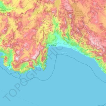
Name: Topografische Karte Antalya, Höhe, Relief.
Ort: Antalya, Mediterranean Region, Turkey (35.92296 29.19166 37.44241 32.62628)
Durchschnittliche Höhe: 644 m
Minimale Höhe: 0 m
Maximale Höhe: 2.923 m
The highest point of the Taurus mountains is Akdağ at an altitude of 3025 metres. Located to the northwest of the city centre and at a distance of 50 km (31 mi) is the Saklıkent ski and recreation centre on Beydağları. Here one can ski and then go down to the shore and into the sea during the months of January–April. In Saklıkent there are two teleski and ski courses along with villas and accommodation facilities available in the area. Situated on Bakırlı Hill behind Saklıkent is the Antalya National Space Observatory. In rivers rafting and canoeing sports and on the Taurus mountains jeep safari, hunting and trekking tours are organised. Alternatively, there is rock-climbing, bird watching tourism, photo-safari, mountain tourism, line fishing and health tourism at the thalasso and dialysis centres in Geyikbayırı. Holy tourism activities are organized in Myra and Patara where St Nicholas was born and lived. The eternal flames of Chimaera that was the inspiration for the Chimera myth is also located in Antalya. In the area of Belek, 30 km (19 mi). east of Antalya, there is a big potential for golf tourism with the bonus of the cultural, historical and natural sightseeing of the region. There are five golf facilities already operating in Belek. There are underwater diving centres on the coast, primarily in Kemer, Çamyuva, Olympos, Adrasan, Kaş, Kalkan, Üçağız, Kekova, Side and Alanya. In addition, yacht tours are organized from the port of Antalya to Düden Waterfall-Karpuzkaldıran and Kemer, from Side to Alanya, from Demre-Çayağzı to Kekova, from Kaş to Kekova, from Kemer to Çıralı-Olympos-Adrasan and Cape Gelidonya. There are also boat tours on Manavgat creek and canoe tours on Xanthos creek. In addition, Blue Cruise, which covers the southwestern Anatolian coast, ends in Antalya. There are ferryboat trips from Alanya to Cyprus and from Antalya to Italy. Antalya today is a tourism centre with touristic accommodation facilities, nature and historic sites.
Andere topografische Karten
Klicken Sie auf eine Karte, um ihre Topografie, ihre Höhe und ihr Relief anzuzeigen.
Sığacık Mahallesi
Sığacık Mahallesi, Seferihisar, Izmir, Aegean Region, Turkey
Durchschnittliche Höhe: 22 m
Dana Island
Dana Island, Silifke, Mersin, Mediterranean Region, Turkey
Durchschnittliche Höhe: 28 m
Sığacık Mahallesi
Sığacık Mahallesi, Bozova, Şanlıurfa, Southeastern Anatolia Region, Turkey
Durchschnittliche Höhe: 523 m
Seyrancık Mahallesi
Seyrancık Mahallesi, Mudurnu, Bolu, Black Sea Region, Turkey
Durchschnittliche Höhe: 970 m
Bademlik Mahallesi
Bademlik Mahallesi, Kırklareli Merkez, Kırklareli, Marmara Region, Turkey
Durchschnittliche Höhe: 259 m
Bağlıca Mahallesi
Bağlıca Mahallesi, Kale, Malatya, Eastern Anatolia Region, Turkey
Durchschnittliche Höhe: 734 m
Yedikule Mahallesi
Yedikule Mahallesi, Istanbul, Fatih, Istanbul, Marmara Region, Turkey
Durchschnittliche Höhe: 15 m
Osmanağa Mahallesi
Osmanağa Mahallesi, Kadıköy, Istanbul, Marmara Region, 34714, Turkey
Durchschnittliche Höhe: 13 m
Bebek Parkı
Bebek Parkı, Bebek Mahallesi, Beşiktaş, Istanbul, Marmara Region, 34342, Turkey
Durchschnittliche Höhe: 63 m
Bebek Çınarlı Bahçe Parkı
Bebek Çınarlı Bahçe Parkı, Bebek Mahallesi, Beşiktaş, Istanbul, Marmara Region, 34342, Turkey
Durchschnittliche Höhe: 65 m
Tophane Mahallesi
Tophane Mahallesi, Alanya, Antalya, Mediterranean Region, Turkey
Durchschnittliche Höhe: 17 m
Beytepe Mahallesi
Beytepe Mahallesi, Ankara, Çankaya, Ankara, Central Anatolia Region, Turkey
Durchschnittliche Höhe: 1.125 m
Eskisehir
Eskisehir, Odunpazarı, Eskişehir, Central Anatolia Region, 26120, Turkey
Durchschnittliche Höhe: 949 m
Aşağıdereköy Mahallesi
Aşağıdereköy Mahallesi, Serdivan, Sakarya, Marmara Region, Turkey
Durchschnittliche Höhe: 168 m
Serdaroğlu
Serdaroğlu, Çaycuma, Zonguldak, Black Sea Region, Turkey
Durchschnittliche Höhe: 72 m
Göbekli Tepe
Göbekli Tepe, Göbeklitepe A B C Tapınak alanı, Göbekli Tepe, Örencik, Haliliye, Şanlıurfa, Southeastern Anatolia Region, Turkey
Durchschnittliche Höhe: 703 m
Kefken Adası
Kefken Adası, Cebeci Mahallesi, Kandıra, Kocaeli, Marmara Region, Turkey
Durchschnittliche Höhe: 2 m
Kavaklıdere Mahallesi
Kavaklıdere Mahallesi, Çankaya, Ankara, Central Anatolia Region, Turkey
Durchschnittliche Höhe: 918 m
Korucuk Mahallesi
Korucuk Mahallesi, Sakarya, Adapazarı, Sakarya, Marmara Region, Turkey
Durchschnittliche Höhe: 87 m
15 Temmuz Camili Mahallesi
15 Temmuz Camili Mahallesi, Nasuhlar, Adapazarı, Sakarya, Marmara Region, Turkey
Durchschnittliche Höhe: 82 m
Beyazit
Turkey > Bahçesaray > Akyayla
Beyazit, Akyayla, Bahçesaray, Van, Eastern Anatolia Region, Turkey
Durchschnittliche Höhe: 1.826 m
Sarayburnu Parkı
Sarayburnu Parkı, Cankurtaran Mahallesi, Istanbul, Fatih, Istanbul, Marmara Region, 34122, Turkey
Durchschnittliche Höhe: 10 m
Atatürk Mahallesi
Atatürk Mahallesi, Çayırova, Kocaeli, Marmara Region, Turkey
Durchschnittliche Höhe: 84 m
Çayırova Mahallesi
Çayırova Mahallesi, Çayırova, Kocaeli, Marmara Region, 41420, Turkey
Durchschnittliche Höhe: 50 m
Kaynarca
Kaynarca, Pınarhisar, Kırklareli, Marmara Region, 39302, Turkey
Durchschnittliche Höhe: 231 m
Beyazıt Mahallesi
Beyazıt Mahallesi, Istanbul, Fatih, Istanbul, Marmara Region, Turkey
Durchschnittliche Höhe: 21 m
Fatih Mahallesi
Fatih Mahallesi, Esenyurt, Istanbul, Marmara Region, Turkey
Durchschnittliche Höhe: 90 m
Çayyolu Mahallesi
Çayyolu Mahallesi, Çankaya, Ankara, Central Anatolia Region, Turkey
Durchschnittliche Höhe: 921 m