
Topografische Karte Vigan
Interaktive Karte
Klicken Sie auf die Karte, um die Höhe anzuzeigen.
Über diese Karte
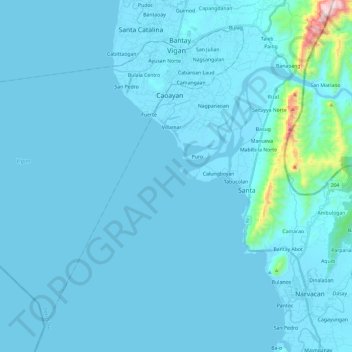
Name: Topografische Karte Vigan, Höhe, Relief.
Ort: Vigan, Ilocos Sur, Ilocos Region, 2700, Philippines (17.39840 120.19585 17.59134 120.43231)
Durchschnittliche Höhe: 34 m
Minimale Höhe: -1 m
Maximale Höhe: 748 m
Vigan is situated in a Quaternary Age sedimentary plain called the Vigan-Bantay Plain which is part of the Ilocos coastal plain. The Vigan-Bantay Plain is bounded on the east by a moderately rugged Miocene sediments consisting of interbedded sandstones and shale to very rugged Meta-volcanics and Meta sediment topography; on the south is the Municipality of Santa where the north–south trending fault terminates; to the west is the South China Sea; while the northern boundary opens to the northern extension of the Ilocos coastal plain.
Andere topografische Karten
Klicken Sie auf eine Karte, um ihre Topografie, ihre Höhe und ihr Relief anzuzeigen.
Magsingal
Magsingal, Ilocos Sur, Ilocos Region, 2730, Philippines
Durchschnittliche Höhe: 18 m