
Topografische Karte Cape Breton County
Interaktive Karte
Klicken Sie auf die Karte, um die Höhe anzuzeigen.
Über diese Karte
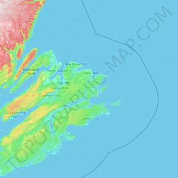
Name: Topografische Karte Cape Breton County, Höhe, Relief.
Durchschnittliche Höhe: 44 m
Minimale Höhe: -3 m
Maximale Höhe: 490 m
Andere topografische Karten
Klicken Sie auf eine Karte, um ihre Topografie, ihre Höhe und ihr Relief anzuzeigen.
Dominion
Canada > Nova Scotia > Cape Breton County > Dominion
Dominion, Cape Breton Regional Municipality, Cape Breton County, Nova Scotia, Canada
Durchschnittliche Höhe: 14 m
Rocky Mountain
Canada > Nova Scotia > Rocky Mountain
Rocky Mountain, Municipality of Pictou County, Pictou County, Nova Scotia, Canada
Durchschnittliche Höhe: 150 m
Cape Breton Island
Canada > Nova Scotia > Margaree Valley
Cape Breton Island, Margaree Valley, Municipality of the County of Inverness, Inverness County, Nova Scotia, Canada
Durchschnittliche Höhe: 66 m
Clarence
Canada > Nova Scotia > Clarence
Clarence, Municipality of the County of Annapolis, Annapolis County, Nova Scotia, B0S 1M0, Canada
Durchschnittliche Höhe: 74 m
Long Point
Canada > Nova Scotia > Long Point
Long Point, Municipality of the County of Inverness, Inverness County, Nova Scotia, Canada
Durchschnittliche Höhe: 85 m
Bras d'Or Lake
Canada > Nova Scotia > Potlotek First Nation
Bras d'Or Lake, Chapel Island 7 Trail, Chapel Island 5, Potlotek First Nation, Richmond County, Nova Scotia, B0E 3B0, Canada
Durchschnittliche Höhe: 0 m