
Topografische Karte Peniel
Interaktive Karte
Klicken Sie auf die Karte, um die Höhe anzuzeigen.
Über diese Karte
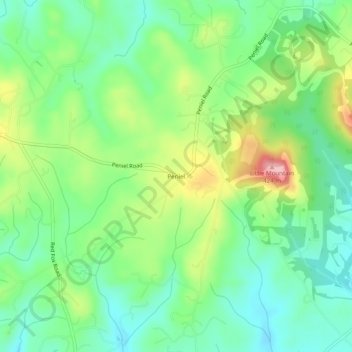
Name: Topografische Karte Peniel, Höhe, Relief.
Ort: Peniel, Polk County, North Carolina, 28722, United States (35.21650 -82.15733 35.25650 -82.11733)
Durchschnittliche Höhe: 326 m
Minimale Höhe: 274 m
Maximale Höhe: 425 m
Andere topografische Karten
Klicken Sie auf eine Karte, um ihre Topografie, ihre Höhe und ihr Relief anzuzeigen.
Saluda
United States > North Carolina > Polk County
Saluda, Polk County, North Carolina, 28773, United States
Durchschnittliche Höhe: 635 m
Tryon
United States > North Carolina > Polk County
Tryon, Polk County, North Carolina, United States
Durchschnittliche Höhe: 333 m
Howard Gap
United States > North Carolina > Polk County
Howard Gap, Polk County, North Carolina, United States
Durchschnittliche Höhe: 573 m