
Spenden
Rüsten Sie sich für Ihr nächstes Abenteuer:
Als Amazon-Partner erhält diese Website eine Provision für qualifizierte Käufe, ohne zusätzliche Kosten für Sie.
Topografische Karte Doanville
Klicken Sie auf die Karte, um die Höhe anzuzeigen.
Spenden
Rüsten Sie sich für Ihr nächstes Abenteuer:
Als Amazon-Partner erhält diese Website eine Provision für qualifizierte Käufe, ohne zusätzliche Kosten für Sie.
Über diese Karte
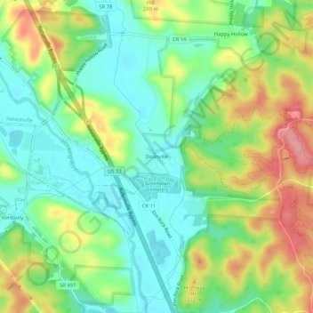
Name: Topografische Karte Doanville, Höhe, Relief.
Ort: Doanville, Athens County, Ohio, 45716, United States (39.41507 -82.21126 39.45507 -82.17126)
Durchschnittliche Höhe: 236 m
Minimale Höhe: 195 m
Maximale Höhe: 302 m
Spenden
Rüsten Sie sich für Ihr nächstes Abenteuer:
Als Amazon-Partner erhält diese Website eine Provision für qualifizierte Käufe, ohne zusätzliche Kosten für Sie.
Andere topografische Karten
Klicken Sie auf eine Karte, um ihre Topografie, ihre Höhe und ihr Relief anzuzeigen.
Spenden
Rüsten Sie sich für Ihr nächstes Abenteuer:
Als Amazon-Partner erhält diese Website eine Provision für qualifizierte Käufe, ohne zusätzliche Kosten für Sie.
Spenden
Rüsten Sie sich für Ihr nächstes Abenteuer:
Als Amazon-Partner erhält diese Website eine Provision für qualifizierte Käufe, ohne zusätzliche Kosten für Sie.
Amesville
United States > Ohio > Athens County
Amesville is situated in the foothills of the Appalachian Mountains, approximately 45 miles south by southeast of the terminal moraine, a topographical feature often associated with the boundaries of glaciers, and is surrounded by wooded hills, narrow valleys, and numerous creeks flanked by lowland pastures…
Durchschnittliche Höhe: 223 m