
Topografische Karte South Lead Hill
Interaktive Karte
Klicken Sie auf die Karte, um die Höhe anzuzeigen.
Über diese Karte
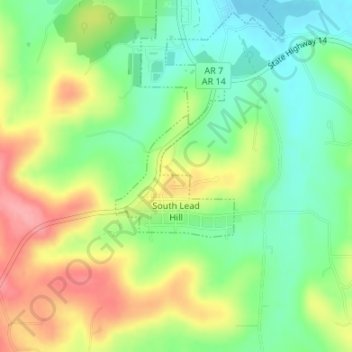
Name: Topografische Karte South Lead Hill, Höhe, Relief.
Durchschnittliche Höhe: 243 m
Minimale Höhe: 200 m
Maximale Höhe: 302 m
Andere topografische Karten
Klicken Sie auf eine Karte, um ihre Topografie, ihre Höhe und ihr Relief anzuzeigen.
Olvey
United States > Arkansas > Boone County
Olvey, Boone County, Arkansas, United States
Durchschnittliche Höhe: 338 m
Omaha
United States > Arkansas > Boone County
Omaha, Boone County, Arkansas, 72662, United States
Durchschnittliche Höhe: 390 m
Valley Springs
United States > Arkansas > Boone County
Valley Springs, Boone County, Arkansas, 72601, United States
Durchschnittliche Höhe: 345 m
Batavia
United States > Arkansas > Boone County
Batavia, Boone County, Arkansas, United States
Durchschnittliche Höhe: 455 m
Diamond City
United States > Arkansas > Boone County
Diamond City, Boone County, Arkansas, 72630, United States
Durchschnittliche Höhe: 223 m
Zinc
United States > Arkansas > Boone County
Zinc, Boone County, Arkansas, 72601, United States
Durchschnittliche Höhe: 324 m
Bellefonte
United States > Arkansas > Boone County
Bellefonte, Boone County, Arkansas, 72601, United States
Durchschnittliche Höhe: 340 m
Bergman
United States > Arkansas > Boone County
Bergman, Boone County, Arkansas, 72601, United States
Durchschnittliche Höhe: 384 m
Alpena
United States > Arkansas > Boone County
Alpena, Boone County, Arkansas, 72611, United States
Durchschnittliche Höhe: 373 m
Capps
United States > Arkansas > Boone County
Capps, Boone County, Arkansas, United States
Durchschnittliche Höhe: 434 m
Everton
United States > Arkansas > Boone County
Everton, Boone County, Arkansas, 72633, United States
Durchschnittliche Höhe: 292 m
Lead Hill
United States > Arkansas > Boone County
Lead Hill, Boone County, Arkansas, United States
Durchschnittliche Höhe: 306 m
Harrison
United States > Arkansas > Boone County
Harrison, Boone County, Arkansas, 72601, United States
Durchschnittliche Höhe: 371 m