
Topografische Karte Hooks Mills
Interaktive Karte
Klicken Sie auf die Karte, um die Höhe anzuzeigen.
Über diese Karte
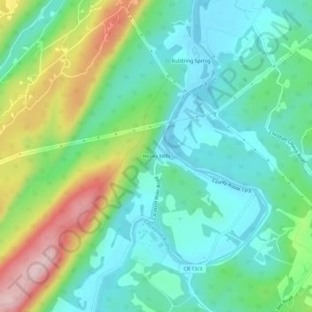
Name: Topografische Karte Hooks Mills, Höhe, Relief.
Durchschnittliche Höhe: 327 m
Minimale Höhe: 247 m
Maximale Höhe: 513 m
Andere topografische Karten
Klicken Sie auf eine Karte, um ihre Topografie, ihre Höhe und ihr Relief anzuzeigen.
Augusta
United States > West Virginia > Hampshire County
Augusta, Hampshire County, West Virginia, 26704, United States
Durchschnittliche Höhe: 380 m
Cacapon River
United States > West Virginia > Hampshire County
Cacapon River, Hampshire County, West Virginia, United States
Durchschnittliche Höhe: 326 m
Spring Gap Mountain
United States > West Virginia > Hampshire County
Spring Gap Mountain, Hampshire County, West Virginia, 25444, United States
Durchschnittliche Höhe: 468 m
Nathaniel Mountain
United States > West Virginia > Hampshire County
Nathaniel Mountain, Hampshire County, West Virginia, United States
Durchschnittliche Höhe: 687 m
Romney
United States > West Virginia > Hampshire County
Romney, Hampshire County, West Virginia, 26757, United States
Durchschnittliche Höhe: 249 m
Levels
United States > West Virginia > Hampshire County > Levels
Levels, Hampshire County, West Virginia, 25431, United States
Durchschnittliche Höhe: 312 m
Sector
United States > West Virginia > Hampshire County
Sector, Hampshire County, West Virginia, United States
Durchschnittliche Höhe: 337 m