Geolokalisieren

Topografische Karte La Petite Forêt

Interaktive Karte

Klicken Sie auf die Karte, um die Höhe anzuzeigen.

Über diese Karte

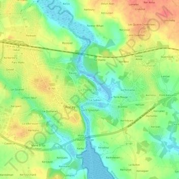
Name: Topografische Karte La Petite Forêt, Höhe, Relief.

Ort: La Petite Forêt, Auray, Lorient, Morbihan, Bretagne, France métropolitaine, 56400, France (47.65032 -2.99687 47.69032 -2.95687)

Durchschnittliche Höhe: 26 m

Minimale Höhe: -11 m

Maximale Höhe: 54 m

Andere topografische Karten

Klicken Sie auf eine Karte, um ihre Topografie, ihre Höhe und ihr Relief anzuzeigen.

Treulen

France > Bretagne > Morbihan > Auray

Treulen, Auray, Lorient, Morbihan, Bretagne, France métropolitaine, 56400, France

Durchschnittliche Höhe: 27 m

Kerberdery

France > Bretagne > Morbihan > Auray

Kerberdery, Auray, Lorient, Morbihan, Bretagne, France métropolitaine, 56400, France

Durchschnittliche Höhe: 28 m

Dakar

France > Bretagne > Morbihan > Auray > Dakar

Dakar, Auray, Lorient, Morbihan, Bretagne, France métropolitaine, 56400, France

Durchschnittliche Höhe: 28 m

Kerbois

France > Bretagne > Morbihan > Auray

Kerbois, Auray, Lorient, Morbihan, Bretagne, France métropolitaine, 56400, France

Durchschnittliche Höhe: 27 m

Le Sablen

France > Bretagne > Morbihan > Auray

Le Sablen, Auray, Lorient, Morbihan, Bretagne, France métropolitaine, 56400, France

Durchschnittliche Höhe: 25 m

La Maison Rouge

France > Bretagne > Morbihan > Auray

La Maison Rouge, Auray, Lorient, Morbihan, Bretagne, France métropolitaine, 56400, France

Durchschnittliche Höhe: 23 m

Kerléano

France > Bretagne > Morbihan > Auray

Kerléano, Auray, Lorient, Morbihan, Bretagne, France métropolitaine, 56400, France

Durchschnittliche Höhe: 25 m

Moncan

France > Bretagne > Morbihan > Auray

Moncan, Auray, Lorient, Morbihan, Bretagne, France métropolitaine, 56400, France

Durchschnittliche Höhe: 23 m

Le Pratel

France > Bretagne > Morbihan > Auray

Le Pratel, Auray, Lorient, Morbihan, Bretagne, France métropolitaine, 56400, France

Durchschnittliche Höhe: 26 m