
Spenden
Rüsten Sie sich für Ihr nächstes Abenteuer:
Als Amazon-Partner erhält diese Website eine Provision für qualifizierte Käufe, ohne zusätzliche Kosten für Sie.
Topografische Karte Southfort
Klicken Sie auf die Karte, um die Höhe anzuzeigen.
Spenden
Rüsten Sie sich für Ihr nächstes Abenteuer:
Als Amazon-Partner erhält diese Website eine Provision für qualifizierte Käufe, ohne zusätzliche Kosten für Sie.
Southfort
It is located at 27°04′05″N 81°57′50″W / 27.068°N 81.964°W / 27.068; -81.964, its elevation 26 feet (7.9 m).
Spenden
Rüsten Sie sich für Ihr nächstes Abenteuer:
Als Amazon-Partner erhält diese Website eine Provision für qualifizierte Käufe, ohne zusätzliche Kosten für Sie.
Über diese Karte
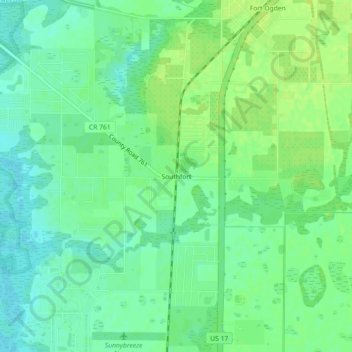
Name: Topografische Karte Southfort, Höhe, Relief.
Ort: Southfort, DeSoto County, Florida, 34269, United States (27.04811 -81.98398 27.08811 -81.94398)
Durchschnittliche Höhe: 9 m
Minimale Höhe: 1 m
Maximale Höhe: 16 m
Spenden
Rüsten Sie sich für Ihr nächstes Abenteuer:
Als Amazon-Partner erhält diese Website eine Provision für qualifizierte Käufe, ohne zusätzliche Kosten für Sie.
Andere topografische Karten
Klicken Sie auf eine Karte, um ihre Topografie, ihre Höhe und ihr Relief anzuzeigen.
Arcadia
United States > Florida > DeSoto County
Arcadia is located slightly northwest of the center of DeSoto County at 27°13'N 81°52'W (27.2176, –81.8599). The Peace River flows past the west side of the city on its way southwest to tidewater at Punta Gorda. Most of Arcadia is more than 40 feet (12 m) above sea level and portions of Arcadia near the…
Durchschnittliche Höhe: 17 m