
Topografische Karte Zavalla
Interaktive Karte
Klicken Sie auf die Karte, um die Höhe anzuzeigen.
Über diese Karte
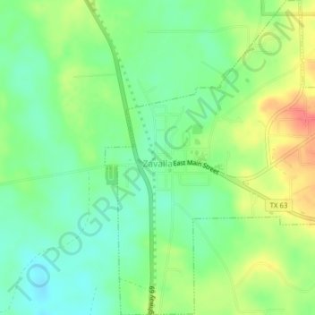
Name: Topografische Karte Zavalla, Höhe, Relief.
Ort: Zavalla, Angelina County, Texas, United States (31.14260 -94.43281 31.17572 -94.40191)
Durchschnittliche Höhe: 76 m
Minimale Höhe: 52 m
Maximale Höhe: 112 m
Andere topografische Karten
Klicken Sie auf eine Karte, um ihre Topografie, ihre Höhe und ihr Relief anzuzeigen.
Shawnee
United States > Texas > Angelina County
Shawnee, Angelina County, Texas, United States
Durchschnittliche Höhe: 75 m
Lufkin
United States > Texas > Angelina County
Lufkin, Angelina County, Texas, United States
Durchschnittliche Höhe: 88 m
Burke
United States > Texas > Angelina County > Burke
Burke, Angelina County, Texas, United States
Durchschnittliche Höhe: 77 m
Pollok
United States > Texas > Angelina County
Pollok, Angelina County, Texas, 75969, United States
Durchschnittliche Höhe: 91 m
Diboll
United States > Texas > Angelina County
Diboll, Angelina County, Texas, 75941, United States
Durchschnittliche Höhe: 67 m
Diboll
United States > Texas > Angelina County > Diboll > Diboll
Diboll, Angelina County, Texas, 75941, United States
Durchschnittliche Höhe: 63 m