
Spenden
Rüsten Sie sich für Ihr nächstes Abenteuer:
Als Amazon-Partner erhält diese Website eine Provision für qualifizierte Käufe, ohne zusätzliche Kosten für Sie.
Topografische Karte Manti
Klicken Sie auf die Karte, um die Höhe anzuzeigen.
Spenden
Rüsten Sie sich für Ihr nächstes Abenteuer:
Als Amazon-Partner erhält diese Website eine Provision für qualifizierte Käufe, ohne zusätzliche Kosten für Sie.
Manti
Manti has a humid continental climate (Köppen Dfb) with warm summers and cold winters, receiving on average barely enough rainfall to avoid a semi-arid classification (BSk). Its high elevation means that the climate is cooler than other populated areas of Utah, especially during summer. Summers highs average in the mid-80s°F, with winter highs in the mid-30s°F. Winter lows, however, dip to around 15–20 °F. Pacific storms move through the region from October through May and spring is the wettest season. However, summer, which is the driest season, primarily relies on precipitation from scattered diurnal thunderstorm activity and the Gulf of California monsoon. Winter and spring see frequent snowfall. Precipitation averages 12.70 inches and snowfall 52.2 inches. The record high temperature is 110 °F (43 °C), set on August 6, 1895, while the record low is −27 °F (−33 °C), set on January 22, 1937.
Spenden
Rüsten Sie sich für Ihr nächstes Abenteuer:
Als Amazon-Partner erhält diese Website eine Provision für qualifizierte Käufe, ohne zusätzliche Kosten für Sie.
Über diese Karte
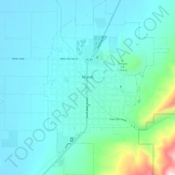
Name: Topografische Karte Manti, Höhe, Relief.
Ort: Manti, Sanpete County, Utah, 84642, United States (39.24447 -111.65052 39.28690 -111.61145)
Durchschnittliche Höhe: 1.743 m
Minimale Höhe: 1.665 m
Maximale Höhe: 2.144 m
Spenden
Rüsten Sie sich für Ihr nächstes Abenteuer:
Als Amazon-Partner erhält diese Website eine Provision für qualifizierte Käufe, ohne zusätzliche Kosten für Sie.
Andere topografische Karten
Klicken Sie auf eine Karte, um ihre Topografie, ihre Höhe und ihr Relief anzuzeigen.