
Topografische Karte Tulancingo de Bravo
Interaktive Karte
Klicken Sie auf die Karte, um die Höhe anzuzeigen.
Über diese Karte
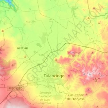
Name: Topografische Karte Tulancingo de Bravo, Höhe, Relief.
Ort: Tulancingo de Bravo, Hidalgo, Mexico (20.05217 -98.50216 20.21230 -98.24656)
Durchschnittliche Höhe: 2.242 m
Minimale Höhe: 1.838 m
Maximale Höhe: 2.753 m
It is located in the Trans-Mexican Volcanic Belt in the Sierra Hidalgo, as it begins its descent to the Gulf of Mexico. It is mostly valley floor with some peaks. This relatively flat surface is mostly of light volcanic rock cut with ravines, small canyons, large hills and volcanoes. The larger canyons include Los Ermitaños, which forms a “Y” over one kilometer long. The highest point is the Cerro del Tezontle, named after the volcanic rock it is principally made up of. Other elevations include Cerro Viejo, Napateco and Las Navajas. The main river is the Tulancingo River, which is part of the Metztitlán River system. There are four small lakes called Los Alamos, Otontepec, San Alejo and La Ciénega.
Andere topografische Karten
Klicken Sie auf eine Karte, um ihre Topografie, ihre Höhe und ihr Relief anzuzeigen.
Sangre de Cristo
Mexico > Hidalgo > Santiago Tulantepec de Lugo Guerrero
Sangre de Cristo, Santiago Tulantepec de Lugo Guerrero, Hidalgo, 43703, Mexico
Durchschnittliche Höhe: 2.413 m
Barrio los Violines
Mexico > Hidalgo > Francisco I. Madero > Tepatepec
Barrio los Violines, Tepatepec, Francisco I. Madero, Hidalgo, Mexico
Durchschnittliche Höhe: 1.989 m
Tamaulipas
Mexico > Hidalgo > Chapulhuacán
Tamaulipas, Chapulhuacán, Hidalgo, Mexico
Durchschnittliche Höhe: 876 m
Mineral de la Reforma
Mineral de la Reforma, Hidalgo, Mexico
Durchschnittliche Höhe: 2.440 m
Tolantongo
Tolantongo, Cardonal, Hidalgo, Mexico
Durchschnittliche Höhe: 1.528 m
San Martín
Mexico > Hidalgo > Agua Blanca de Iturbide
San Martín, Agua Blanca de Iturbide, Hidalgo, Mexico
Durchschnittliche Höhe: 1.795 m
Tepeji del Río de Ocampo
Tepeji del Río de Ocampo, Hidalgo, Mexico
Durchschnittliche Höhe: 2.296 m
Jahuey Capula
Mexico > Hidalgo > Ixmiquilpan
Jahuey Capula, Ixmiquilpan, Hidalgo, Mexico
Durchschnittliche Höhe: 1.780 m
Col. Loma Bonita
Mexico > Hidalgo > Atotonilco de Tula > Atotonilco de Tula > Col. Loma Bonita
Col. Loma Bonita, Atotonilco de Tula, Hidalgo, 42900, Mexico
Durchschnittliche Höhe: 2.164 m
Cholula
Mexico > Hidalgo > Tianguistengo > Cholula
Cholula, Tianguistengo, Hidalgo, Mexico
Durchschnittliche Höhe: 1.266 m
Tecoluco Calpan
Mexico > Hidalgo > Tecoluco Calpan
Tecoluco Calpan, Huautla, Hidalgo, Mexico
Durchschnittliche Höhe: 178 m
La Crucita
Mexico > Hidalgo > Pachuquilla
La Crucita, Pachuquilla, Mineral de la Reforma, Hidalgo, 42184, Mexico
Durchschnittliche Höhe: 2.567 m
Mineral del Chico
Mineral del Chico, Hidalgo, 42120, Mexico
Durchschnittliche Höhe: 2.404 m
Tula de Allende
Mexico > Hidalgo > Tula de Allende
Tula de Allende, Hidalgo, 42831, Mexico
Durchschnittliche Höhe: 2.100 m
El Cerrote
Mexico > Hidalgo > Zimapán > El Cerrote
El Cerrote, Zimapán, Hidalgo, Mexico
Durchschnittliche Höhe: 2.511 m
MESA GRANDE
MESA GRANDE, Ajacuba, Hidalgo, Mexico
Durchschnittliche Höhe: 2.288 m
Pachuca
Mexico > Hidalgo > Pachuca de Soto
Pachuca, Pachuca de Soto, Hidalgo, 42040, Mexico
Durchschnittliche Höhe: 2.459 m