
Topografische Karte Cuddalore
Klicken Sie auf die Karte, um die Höhe anzuzeigen.
Cuddalore
Cuddalore is located at 11°45′N 79°45′E / 11.75°N 79.75°E / 11.75; 79.75. It has an average elevation of 6 m (20 ft). The land is completely flat with large deposits of black and alluvial soil inland and coarse sand near the seashore. The sandstone deposits in the town are popular. The Pennayar River runs north of the town, while Gadilam River runs across it. Cuddalore is situated at a distance of 200 km (120 mi) from the state capital Chennai and 18 km (11 mi) from Puducherry, the neighbouring union territory. The nearest airport is at Chennai, 200 kilometres (120 mi) from Cuddalore. The period from November to February in Cuddalore is pleasant, with a climate full of warm days and cool nights. The onset of summer is from March, with the mercury reaching its peak by the end of May and June. The average temperatures range from 37 °C (99 °F) in January to 22.5 °C (72.5 °F) in May and June. Summer rains are sparse and the first monsoon, the South-West monsoon, sets in June and continues till September. North-East monsoon sets in October and continues till January. The rainfall during South-West monsoon period is much lower than that of North-East monsoon. The average rainfall is 1,400 mm (55 in), most of which is contributed by the North-East monsoon.
Über diese Karte
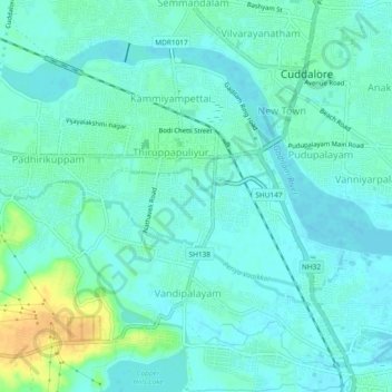
Name: Topografische Karte Cuddalore, Höhe, Relief.
Ort: Cuddalore, Cuddalore district, Tamil Nadu, 607002, India (11.72623 79.72313 11.75814 79.76974)
Durchschnittliche Höhe: 8 m
Minimale Höhe: -1 m
Maximale Höhe: 32 m