
Topografische Karte Municipal Unit of Nea Kios
Interaktive Karte
Klicken Sie auf die Karte, um die Höhe anzuzeigen.
Über diese Karte
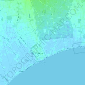
Name: Topografische Karte Municipal Unit of Nea Kios, Höhe, Relief.
Durchschnittliche Höhe: 2 m
Minimale Höhe: -3 m
Maximale Höhe: 9 m
Andere topografische Karten
Klicken Sie auf eine Karte, um ihre Topografie, ihre Höhe und ihr Relief anzuzeigen.
Nafplio
Greece > Peloponnese, Western Greece and the Ionian > Argolis Regional Unit > Municipal Unit of Nafplio
Nafplio, Municipal Unit of Nafplio, Municipality of Nafplio, Argolis Regional Unit, Peloponnese Region, Peloponnese, Western Greece and the Ionian, 211 00, Greece
Durchschnittliche Höhe: 36 m
Myli
Greece > Peloponnese, Western Greece and the Ionian > Argolis Regional Unit > Municipal Unit of Lerna
Myli, Municipal Unit of Lerna, Municipality of Argos and Mykines, Argolis Regional Unit, Peloponnese Region, Peloponnese, Western Greece and the Ionian, 212 00, Greece
Durchschnittliche Höhe: 31 m
Municipal Unit of Mykines
Greece > Peloponnese, Western Greece and the Ionian > Argolis Regional Unit
Municipal Unit of Mykines, Municipality of Argos and Mykines, Argolis Regional Unit, Peloponnese Region, Peloponnese, Western Greece and the Ionian, Greece
Durchschnittliche Höhe: 312 m
Kilada
Greece > Peloponnese, Western Greece and the Ionian > Argolis Regional Unit > Municipal Unit of Kranidi
Kilada, Municipal Unit of Kranidi, Municipality of Ermionida, Argolis Regional Unit, Peloponnese Region, Peloponnese, Western Greece and the Ionian, 213 00, Greece
Durchschnittliche Höhe: 17 m