
Topografische Karte Covington
Interaktive Karte
Klicken Sie auf die Karte, um die Höhe anzuzeigen.
Über diese Karte
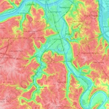
Name: Topografische Karte Covington, Höhe, Relief.
Ort: Covington, Kenton County, Kentucky, United States (38.96456 -84.55480 39.09768 -84.47971)
Durchschnittliche Höhe: 216 m
Minimale Höhe: 139 m
Maximale Höhe: 285 m
Andere topografische Karten
Klicken Sie auf eine Karte, um ihre Topografie, ihre Höhe und ihr Relief anzuzeigen.
Ludlow
United States > Kentucky > Kenton County
Ludlow, Kenton County, Kentucky, 41016, United States
Durchschnittliche Höhe: 182 m
Morning View
United States > Kentucky > Kenton County
Morning View, Kenton County, Kentucky, 41063, United States
Durchschnittliche Höhe: 192 m
Villa Hills
United States > Kentucky > Kenton County
Villa Hills, Kenton County, Kentucky, United States
Durchschnittliche Höhe: 224 m
Taylor Mill
United States > Kentucky > Kenton County
Taylor Mill, Kenton County, Kentucky, 41015, United States
Durchschnittliche Höhe: 211 m
Sunny Acres
United States > Kentucky > Kenton County > Taylor Mill > Sunny Acres
Sunny Acres, Taylor Mill, Kenton County, Kentucky, 41015, United States
Durchschnittliche Höhe: 216 m
Lakeside Park
United States > Kentucky > Kenton County
Lakeside Park, Kenton County, Kentucky, 41017, United States
Durchschnittliche Höhe: 255 m