Geolokalisieren

Topografische Karte Oldham County

Interaktive Karte

Klicken Sie auf die Karte, um die Höhe anzuzeigen.

Über diese Karte

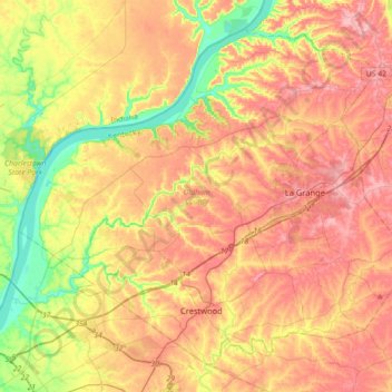
Name: Topografische Karte Oldham County, Höhe, Relief.

Ort: Oldham County, Kentucky, USA (38.28530 -85.63788 38.52398 -85.28281)

Durchschnittliche Höhe: 212 m

Minimale Höhe: 123 m

Maximale Höhe: 289 m

Andere topografische Karten

Klicken Sie auf eine Karte, um ihre Topografie, ihre Höhe und ihr Relief anzuzeigen.

Webster County

USA > Kentucky

Webster County, Kentucky, USA

Durchschnittliche Höhe: 130 m

Forest Hills

USA > Kentucky > Forest Hills

Forest Hills, Jefferson County, Kentucky, USA

Durchschnittliche Höhe: 202 m

Fonthill

USA > Kentucky > Fonthill

Fonthill, Russell County, Kentucky, USA

Durchschnittliche Höhe: 302 m

Elkfork

USA > Kentucky > Elkfork

Elkfork, Morgan County, Kentucky, 41421, USA

Durchschnittliche Höhe: 300 m

Mammoth Cave

USA > Kentucky > Mammoth Cave

Mammoth Cave, Edmonson County, Kentucky, USA

Durchschnittliche Höhe: 214 m

Edmonton

USA > Kentucky > Edmonton

Edmonton, Metcalfe County, Kentucky, 42129, USA

Durchschnittliche Höhe: 254 m

Brent

USA > Kentucky > Brent

Brent, Campbell County, Kentucky, 45228, USA

Durchschnittliche Höhe: 199 m

Edgewood

USA > Kentucky > Edgewood

Edgewood, Kenton County, Kentucky, USA

Durchschnittliche Höhe: 258 m

Bell County

USA > Kentucky

Bell County, Kentucky, USA

Durchschnittliche Höhe: 498 m

Hopkins County

USA > Kentucky

Hopkins County, Kentucky, USA

Durchschnittliche Höhe: 134 m

Ulysses

USA > Kentucky > Ulysses

Ulysses, Lawrence County, Kentucky, 41264, USA

Durchschnittliche Höhe: 238 m

Sewellton

USA > Kentucky > Sewellton

Sewellton, Russell County, Kentucky, 42629, USA

Durchschnittliche Höhe: 289 m

Deadman's Island

USA > Kentucky

Deadman's Island, Henderson County, Kentucky, USA

Durchschnittliche Höhe: 112 m

Corbin

USA > Kentucky > Corbin

Corbin, Whitley County, Kentucky, USA

Durchschnittliche Höhe: 360 m

Guy

USA > Kentucky > Guy

Guy, Warren County, Kentucky, USA

Durchschnittliche Höhe: 152 m

Music

USA > Kentucky > Music

Music, Carter County, Kentucky, USA

Durchschnittliche Höhe: 264 m

Dawkins

USA > Kentucky > Dawkins

Dawkins, Johnson County, Kentucky, 41268, USA

Durchschnittliche Höhe: 238 m

Stephens Lake

USA > Kentucky > Beelerton

Stephens Lake, Hicks Road, Beelerton, Hickman County, Kentucky, 42085, USA

Durchschnittliche Höhe: 112 m

Murray Hill

USA > Kentucky > Murray Hill

Murray Hill, Jefferson County, Kentucky, USA

Durchschnittliche Höhe: 194 m

Georgetown

USA > Kentucky > Georgetown

Georgetown, Scott County, Kentucky, 40324, USA

Durchschnittliche Höhe: 265 m