
Topografische Karte Sahel
Interaktive Karte
Klicken Sie auf die Karte, um die Höhe anzuzeigen.
Über diese Karte
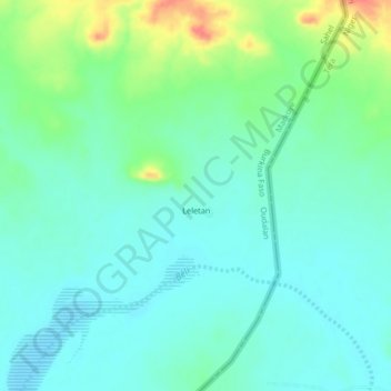
Name: Topografische Karte Sahel, Höhe, Relief.
Ort: Sahel, Markoye, Oudalan, Sahel, Burkina Faso (13.89555 -0.77157 15.89555 1.22843)
Durchschnittliche Höhe: 279 m
Minimale Höhe: 204 m
Maximale Höhe: 492 m
The topography of the Sahel is mainly flat; most of the region lies between 200 and 400 meters (660 and 1,310 ft) in elevation. Several isolated plateaus and mountain ranges rise from the Sahel, but are designated as separate ecoregions because their flora and fauna are distinct from the surrounding lowlands. Annual rainfall varies from around 100–200 mm (4–8 in) in the north of the Sahel to around 700–1,000 mm (28–39 in) in the south.
Andere topografische Karten
Klicken Sie auf eine Karte, um ihre Topografie, ihre Höhe und ihr Relief anzuzeigen.
Konga
Konga, Gomboro, Sourou, Boucle du Mouhoun, Burkina Faso
Durchschnittliche Höhe: 296 m
Fabédougou
Fabédougou, Bérégadougou, Comoé, Waterfalls, Burkina Faso
Durchschnittliche Höhe: 333 m
Dômes de Fabedougou
Dômes de Fabedougou, Bérégadougou, Comoé, Waterfalls, Burkina Faso
Durchschnittliche Höhe: 333 m
Soubakaniédougou
Soubakaniédougou, Comoé, Waterfalls, Burkina Faso
Durchschnittliche Höhe: 309 m
Dédougou
Dédougou, Mouhoun, Boucle du Mouhoun, Burkina Faso
Durchschnittliche Höhe: 298 m