
Topografische Karte Mayabunder
Interaktive Karte
Klicken Sie auf die Karte, um die Höhe anzuzeigen.
Über diese Karte
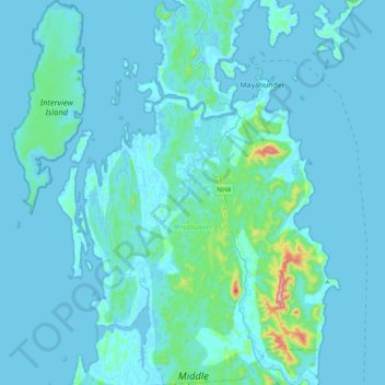
Name: Topografische Karte Mayabunder, Höhe, Relief.
Durchschnittliche Höhe: 27 m
Minimale Höhe: -2 m
Maximale Höhe: 468 m
Andere topografische Karten
Klicken Sie auf eine Karte, um ihre Topografie, ihre Höhe und ihr Relief anzuzeigen.
Andaman Islands
India > Andaman and Nicobar Islands
Andaman Islands, Andaman and Nicobar Islands, India
Durchschnittliche Höhe: 2 m
South Andaman
India > Andaman and Nicobar Islands > Ferrargunj
South Andaman, Wimberleyganj, Ferrargunj, South Andaman District, Andaman and Nicobar Islands, India
Durchschnittliche Höhe: 17 m
North Sentinel Island
India > Andaman and Nicobar Islands > Ferrargunj
North Sentinel Island, Ferrargunj, South Andaman District, Andaman and Nicobar Islands, India
Durchschnittliche Höhe: 20 m
South Andaman Island
India > Andaman and Nicobar Islands > Ferrargunj
South Andaman Island, Ferrargunj, South Andaman, Andaman and Nicobar Islands, India
Durchschnittliche Höhe: 13 m
Nicobar Islands
India > Andaman and Nicobar Islands
Nicobar Islands, Great Nicobar, Nicobar, Andaman and Nicobar Islands, India
Durchschnittliche Höhe: 2 m
Car Nicobar Island
India > Andaman and Nicobar Islands > Car Nicobar > Sawal
Car Nicobar Island, Sawal, Car Nicobar, Nicobar District, Andaman and Nicobar Islands, India
Durchschnittliche Höhe: 11 m
South Brother Island
India > Andaman and Nicobar Islands
South Brother Island, Little Andaman, South Andaman, Andaman and Nicobar Islands, India
Durchschnittliche Höhe: 1 m
Wandoor
India > Andaman and Nicobar Islands > Wandoor
Wandoor, Ferrargunj, South Andaman, Andaman and Nicobar Islands, India
Durchschnittliche Höhe: 13 m
Great Nicobar Island
India > Andaman and Nicobar Islands
Great Nicobar Island, Andaman and Nicobar Islands, India
Durchschnittliche Höhe: 32 m
Mayabunder
India > Andaman and Nicobar Islands > Mayabunder
Mayabunder, Andaman and Nicobar Islands, India
Durchschnittliche Höhe: 8 m
Great Channel
India > Andaman and Nicobar Islands
Great Channel, Andaman and Nicobar Islands, India
Durchschnittliche Höhe: 0 m