
Topografische Karte Chittorgarh
Interaktive Karte
Klicken Sie auf die Karte, um die Höhe anzuzeigen.
Über diese Karte
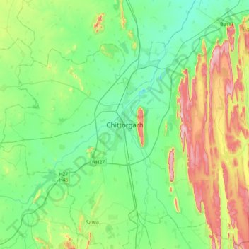
Name: Topografische Karte Chittorgarh, Höhe, Relief.
Durchschnittliche Höhe: 442 m
Minimale Höhe: 371 m
Maximale Höhe: 617 m
Chittorgarh is located at 24°53′N 74°38′E / 24.88°N 74.63°E / 24.88; 74.63. It has an average elevation of 394 metres (1292 ft).Chittorgarh is located in the southern part of the state of Rajasthan, in the northwestern part of India. It is located beside a high hill near the Gambhiri River. Chittorgarh is located between 23° 32' and 25° 13' north latitudes and between 74° 12' and 75° 49' east longitudes in the southeastern part of Rajasthan state. The district encompasses 350.8 square km (3.17 per cent of the Rajasthan State) area of land.
Andere topografische Karten
Klicken Sie auf eine Karte, um ihre Topografie, ihre Höhe und ihr Relief anzuzeigen.
Eral
India > Rajasthan > Chittaurgarh Tehsil
Eral, Chittaurgarh Tehsil, Chittorgarh District, Rajasthan, India
Durchschnittliche Höhe: 424 m
Chittauri Ka Khera
India > Rajasthan > Chittaurgarh Tehsil > Chittauri > Chittauri Ka Khera
Chittauri Ka Khera, Chittauri, Chittaurgarh Tehsil, Chittorgarh, Rajasthan, India
Durchschnittliche Höhe: 414 m
Garol
India > Rajasthan > Chittaurgarh Tehsil > Garol
Garol, Chittaurgarh Tehsil, Chittorgarh, Rajasthan, India
Durchschnittliche Höhe: 460 m
Chittorgarh Fort
India > Rajasthan > Chittaurgarh Tehsil > Chittauri > Chittauri Ka Khera
Chittorgarh Fort, MDR209, Chittauri Ka Khera, Chittauri, Chittaurgarh Tehsil, Chittorgarh, Rajasthan, 312001, India
Durchschnittliche Höhe: 427 m