
Topografische Karte Karpenisi
Interaktive Karte
Klicken Sie auf die Karte, um die Höhe anzuzeigen.
Über diese Karte
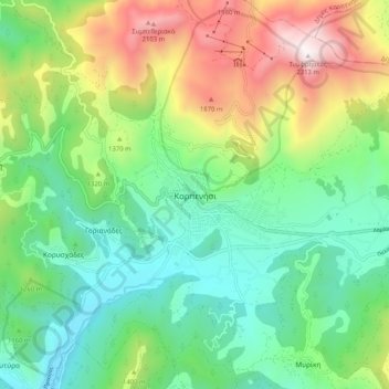
Name: Topografische Karte Karpenisi, Höhe, Relief.
Durchschnittliche Höhe: 1.236 m
Minimale Höhe: 710 m
Maximale Höhe: 2.301 m
Karpenisi (Greek: Καρπενήσι, Greek pronunciation: [karpeˈnisi]) is a town in central Greece. It is the capital of the regional unit of Evrytania. Karpenisi is situated in the valley of the river Karpenisiotis (Καρπενησιώτης), a tributary of the Megdovas, in the southern part of the Pindus Mountains. Mount Tymfristos (2,315 m elevation) lies directly to the north of the town, and the foothills of mount Kaliakouda are in the south. Karpenisi has a ski resort and is a popular destination, especially during winter. It is called Switzerland of Greece for the resemblance with the mountainous country and its beauty, atypical for a Mediterranean place.
Andere topografische Karten
Klicken Sie auf eine Karte, um ihre Topografie, ihre Höhe und ihr Relief anzuzeigen.
Valaora
Greece > Thessaly and Central Greece > Regional Unit of Evrytania
Valaora, Agrafa Municipality, Regional Unit of Evrytania, Central Greece, Thessaly and Central Greece, 360 72, Greece
Durchschnittliche Höhe: 464 m