
Topografische Karte Russellville
Interaktive Karte
Klicken Sie auf die Karte, um die Höhe anzuzeigen.
Über diese Karte
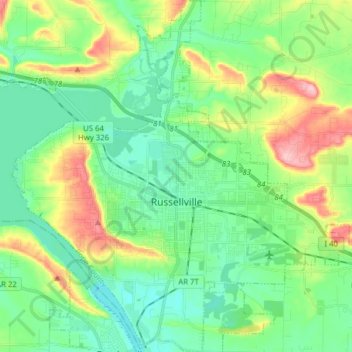
Name: Topografische Karte Russellville, Höhe, Relief.
Ort: Russellville, Pope County, Arkansas, United States (35.22398 -93.20698 35.35133 -93.06183)
Durchschnittliche Höhe: 133 m
Minimale Höhe: 85 m
Maximale Höhe: 246 m
Andere topografische Karten
Klicken Sie auf eine Karte, um ihre Topografie, ihre Höhe und ihr Relief anzuzeigen.
Smyrna
United States > Arkansas > Pope County
Smyrna, Pope County, Arkansas, United States
Durchschnittliche Höhe: 402 m
Dover
United States > Arkansas > Pope County
Dover, Pope County, Arkansas, 72837, United States
Durchschnittliche Höhe: 164 m
Dover
United States > Arkansas > Pope County > Dover > Dover
Dover, Pope County, Arkansas, 72837, United States
Durchschnittliche Höhe: 150 m
Moreland
United States > Arkansas > Pope County > Moreland
Moreland, Pope County, Arkansas, 72802:72837, United States
Durchschnittliche Höhe: 236 m
Worthen
United States > Arkansas > Pope County > Pottsville
Worthen, Pottsville, Pope County, Arkansas, 72858, United States
Durchschnittliche Höhe: 143 m