
Topografische Karte Michelmersh and Timsbury
Interaktive Karte
Klicken Sie auf die Karte, um die Höhe anzuzeigen.
Über diese Karte
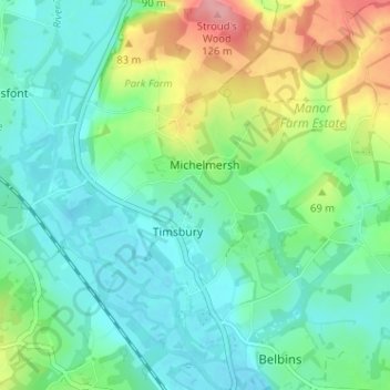
Name: Topografische Karte Michelmersh and Timsbury, Höhe, Relief.
Durchschnittliche Höhe: 46 m
Minimale Höhe: 15 m
Maximale Höhe: 123 m
Andere topografische Karten
Klicken Sie auf eine Karte, um ihre Topografie, ihre Höhe und ihr Relief anzuzeigen.
Redenham
United Kingdom > England > Test Valley > Redenham
Redenham, Test Valley, Hampshire, South East, England, SP11 9AY, United Kingdom
Durchschnittliche Höhe: 113 m
Romsey and Southampton North
United Kingdom > England > Test Valley
Romsey and Southampton North, Bossington, Test Valley, Hampshire, South East, England, United Kingdom
Durchschnittliche Höhe: 75 m
Kimpton
United Kingdom > England > Test Valley
Kimpton, Test Valley, Hampshire, South East, England, United Kingdom
Durchschnittliche Höhe: 111 m
Toot Hill
United Kingdom > England > Test Valley
Toot Hill, Test Valley, Hampshire, South East, England, SO16 8AL, United Kingdom
Durchschnittliche Höhe: 45 m
River Dever
United Kingdom > England > Test Valley
River Dever, Test Valley, Hampshire, South East, England, SO21 3QG, United Kingdom
Durchschnittliche Höhe: 74 m
Houghton
United Kingdom > England > Test Valley
Houghton, Test Valley, Hampshire, South East, England, United Kingdom
Durchschnittliche Höhe: 61 m
Nursling and Rownhams
United Kingdom > England > Test Valley
Nursling and Rownhams, Test Valley, Hampshire, South East, England, United Kingdom
Durchschnittliche Höhe: 31 m
Valley Park
United Kingdom > England > Test Valley
Valley Park, Test Valley, Hampshire, South East, England, United Kingdom
Durchschnittliche Höhe: 37 m